Category:The Octagon, Grove Street
Jump to navigation
Jump to search
| Object location | | View all coordinates using: OpenStreetMap |
|---|
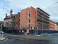
1867 brick house, Grade II listed, featuring several innovations in house building, most notably central heating.
architectural structure in Liverpool, Merseyside, England, UK  | |||||
| Upload media | |||||
| Instance of | |||||
|---|---|---|---|---|---|
| Location | Liverpool, Merseyside, North West England, England | ||||
| Heritage designation |
| ||||
 | |||||
Media in category "The Octagon, Grove Street"
The following 9 files are in this category, out of 9 total.
-
 Corner of Grove Street and Myrtle Street (109158873).jpg 2,012 × 1,207; 932 KB
-
 Octagon Building and Hayward House 04 Aug 2013.jpg 4,288 × 3,216; 2.35 MB
-
 Rear of The Octagon, Grove Street.jpg 3,456 × 4,936; 8.66 MB
-
 Research Institute & Urban Sleep build, Liverpool, 02 March 201.jpg 4,288 × 3,216; 2.55 MB
-
 Research Institute, Grove Street, Liverpool Feb 18 2010.jpg 2,304 × 3,072; 1.17 MB
-
 Research Institute, Liverpool, 17 December, 2012.jpg 4,288 × 3,216; 1.55 MB
-
 The Octagon, Grove Street 1.jpg 3,306 × 3,477; 5.07 MB
-
 The Octagon, Grove Street 2.jpg 4,512 × 3,760; 8.69 MB
-
 The Octagon, Grove Street 3.jpg 3,936 × 3,576; 6.27 MB
.jpg)


