Category:The Lands of Roughwood
Jump to navigation
Jump to search
English: Roughwood once Ruchwood is a farm, once a small estate, possessing a small tower castle, lying outside the town of Beith in North Ayrshire, Scotland. The lands lay within the old Lordship of Giffen.
castle in North Ayrshire, Scotland, UK  | |||||
| Upload media | |||||
| Instance of | |||||
|---|---|---|---|---|---|
| Location | North Ayrshire, Scotland | ||||
 | |||||
Media in category "The Lands of Roughwood"
The following 20 files are in this category, out of 20 total.
-
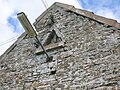
 Blind gun loop at Roughwood.JPG 2,288 × 1,712; 1.31 MB
-
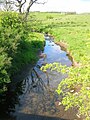
 Burnside from Roughwood.JPG 2,288 × 1,712; 1.74 MB
-
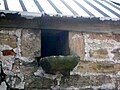
 Dovecot at Roughwood.JPG 2,288 × 1,712; 1.32 MB
-
 Hammil of Roughwood Coat of Arms.jpg 1,056 × 1,312; 244 KB
-
 Owl hole - perch or landing platform.JPG 2,288 × 1,712; 1.28 MB
-
 Owl Hole - Roughwood.JPG 2,284 × 1,706; 1.43 MB
-
 Powgree Burn at Roughwood Bridge.JPG 1,712 × 2,288; 1.27 MB
-
 Roughwood - blocked doorway.JPG 1,712 × 2,288; 1.21 MB
-
 Roughwood - old door.JPG 2,288 × 1,712; 1.32 MB
-
 Roughwood - old doorway.JPG 1,712 × 2,288; 1.28 MB
-
 Roughwood - old part of the farm buildings.JPG 2,288 × 1,712; 1.6 MB
-
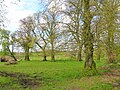 Roughwood - old plantations.JPG 2,288 × 1,712; 2.83 MB
-
 Roughwood - site of limestone quarry.JPG 2,288 × 1,712; 2.01 MB
-
 Roughwood Bridge over the Powgree Burn.JPG 2,288 × 1,712; 1.43 MB
-
 Roughwood Farm from entrance.JPG 2,288 × 1,712; 2.4 MB
-
 Roughwood Farm.JPG 2,288 × 1,712; 1.25 MB
-
 Roughwood from the lane.JPG 2,288 × 1,712; 1.74 MB
-
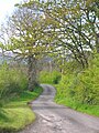 Roughwood Road looking towards Burnside.JPG 1,712 × 2,288; 1.31 MB
-
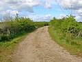
 Roughwood Road looking towards DM Beith.JPG 2,288 × 1,712; 2.13 MB
-
 Spiersland Way.JPG 2,288 × 1,712; 2.18 MB


