Category:The Howlands Butte
Jump to navigation
Jump to search

(Wotans Throne prominence behind)

Summit in Coconino County, Arizona | |||||
| Upload media | |||||
| Location | Arizona | ||||
|---|---|---|---|---|---|
 | |||||
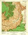
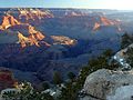
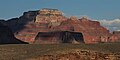
English: The Howlands Butte — the butte is a monolith, standing alone, over Granite Gorge to its south. The prominence is not easily identified: it contains slopes of (dk brick red) Hermit Formation, on a platform, with a very minor remnant of Coconino Sandstone.
- The platform on top of Supai Group - redbeds, on top of Redwall Limestone cliffs —- is the prominence’s base; the butte is at the southeast of (south-southwest-flowing) Clear Creek (that separates a sub-plateau from the Walhalla Plateau, of the southeast Kaibab Plateau). Wotans Throne and Cape Royal are headwater sources of Clear Creek.
On The Howlands Butte's southeast is (small, and short)-Eightythree Mile Canyon, with three prominences on its southeast: Angels Gate, Dunn Butte, and Hawkins Butte (overlooking Granite Gorge). Angels Gate is north, away from Granite Gorge, and adjacent Wotans Throne, and Angels Gate is also a headwater source to Clear Creek Canyon.
- The platform on top of Supai Group - redbeds, on top of Redwall Limestone cliffs —- is the prominence’s base; the butte is at the southeast of (south-southwest-flowing) Clear Creek (that separates a sub-plateau from the Walhalla Plateau, of the southeast Kaibab Plateau). Wotans Throne and Cape Royal are headwater sources of Clear Creek.
Subcategories
This category has the following 3 subcategories, out of 3 total.
Media in category "The Howlands Butte"
The following 30 files are in this category, out of 30 total.
-
 00469 Grand Canyon Shoshone Point (historic) (7789068352).jpg 1,024 × 719; 246 KB
-
 Arizona. LOC 99446124-2.jpg 6,471 × 8,018; 12.08 MB
-
 Arizona. LOC 99446126-11.jpg 4,883 × 6,157; 6.27 MB
-
 Arizona. LOC 99446126-2.jpg 5,014 × 6,252; 6.24 MB
-

-
 Clear Creek Grand Canyon.jpg 6,797 × 2,485; 16.94 MB
-
 GC SR overzicht.jpg 700 × 525; 135 KB
-
 Grand Canyon (Grand Canyon National Park Service).jpg 3,691 × 1,945; 3.51 MB
-
 Grand Canyon 20060612.jpg 3,504 × 2,336; 2.85 MB
-
 Grand Canyon from Grandview Point-panorama.jpeg 2,000 × 623; 142 KB
-
 Grand Canyon from Moran Point.jpeg 2,000 × 824; 231 KB
-
 Grand Canyon Nat Park Clear Creek Trail Construction 1934 (6843470311).jpg 1,000 × 666; 289 KB
-
 Grand Canyon national park 1.jpg 4,032 × 3,024; 3.35 MB
-
 Grand Canyon National Park Yaki Point - View to the East 0271 (7572483120).jpg 6,400 × 5,252; 6.73 MB
-
 Grand Canyon Ridge and O'Neill Butte.jpg 2,500 × 1,667; 2.34 MB
-
 Grand Canyon South Rim 4.JPG 1,600 × 1,200; 402 KB
-
 Grand Canyon South Rim Wotans Vishnu.jpg 3,930 × 2,697; 2.91 MB
-
 Grand Canyon with Snow 15.JPG 4,000 × 3,000; 2.43 MB
-
 Grand Canyon-The Howlands Butte.jpg 5,184 × 3,456; 6.11 MB
-
 Grand canyons sunset yaki point.jpg 1,280 × 960; 257 KB
-
 Grandcanyon view5.jpg 1,969 × 1,410; 579 KB
-
 Harvey Butchart's hiking map - Flickr - brewbooks (8).jpg 3,264 × 2,448; 3.73 MB
-
 Panorama du Grand Canyon de soir.JPG 9,231 × 2,332; 5.01 MB
-
 The Grand Canyon - panoramio.jpg 2,048 × 1,536; 872 KB
-
 The Howlands Butte viewed from Clear Creek Trail.jpg 1,024 × 768; 768 KB
-
 The Howlands Butte, Redwall Limestone, Grand Canyon (view from the South Rim).jpg 3,008 × 2,000; 4.04 MB
-
 The Howlands Butte.jpg 2,726 × 1,375; 922 KB
-
 USAF C-131 (9553493414).jpg 4,261 × 2,860; 17.32 MB
-
 Wotans Throne and Angels Gate.jpg 2,485 × 1,244; 698 KB
-
 Yaqui Point Grand Canyon sunrise 1986.jpg 969 × 658; 498 KB
_(7789068352).jpg)


.jpg)

.jpg)


.jpg)

.jpg)

.jpg)


,_The_Howlands_Butte,_Ottoman_Amphitheater,_Angels_Gate,_Zoroaster,_Brahma,_and_Deva_Temples_prominences.png)
.jpg)