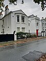
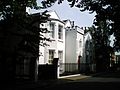
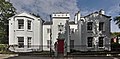
Category:The Friary, Liverpool 17
Jump to navigation
Jump to search
| Object location | | View all coordinates using: OpenStreetMap |
|---|
architectural structure in Liverpool, Merseyside, England, UK  | |||||
| Upload media | |||||
| Instance of | |||||
|---|---|---|---|---|---|
| Location | Liverpool, Merseyside, North West England, England | ||||
| Heritage designation |
| ||||
 | |||||
Media in category "The Friary, Liverpool 17"
The following 4 files are in this category, out of 4 total.
-
 The Friary Or The Glebelands.jpg 3,024 × 4,032; 3.93 MB
-
 The Friary, Liverpool 17 (a).jpg 2,048 × 1,536; 1.55 MB
-
 The Friary, Liverpool 17 (b).jpg 2,048 × 1,536; 1.51 MB
-
 The Friary, St Michael's Hamlet 2020.jpg 6,066 × 3,007; 12.38 MB

.jpg)
.jpg)