Category:The Clarence, Bootle
Jump to navigation
Jump to search
| Object location | | View all coordinates using: OpenStreetMap |
|---|
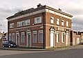
Former pub at the corner of Bridge Street and Canal Street, Bootle.
Media in category "The Clarence, Bootle"
The following 2 files are in this category, out of 2 total.
-
 Benchmark at The Clarence, Bootle.jpg 3,462 × 4,955; 22.79 MB
-
 The Clarence, Bootle.jpg 4,921 × 3,444; 19.17 MB

