Category:The Arkles
Jump to navigation
Jump to search
| Object location | | View all coordinates using: OpenStreetMap |
|---|
pub in Liverpool, Merseyside, England, UK  | |||||
| Upload media | |||||
| Instance of | |||||
|---|---|---|---|---|---|
| Location | Anfield, Liverpool, Merseyside, North West England, England | ||||
| Street address |
| ||||
| Owned by | |||||
| Heritage designation |
| ||||
 | |||||
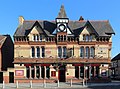
This is a category about listed building number 1356258. |
Grade II listed 1880s public house in yellow brick with red brick and stone dressings and slate roof.
Media in category "The Arkles"
The following 3 files are in this category, out of 3 total.
-
 The Arkles 1.jpg 4,774 × 3,550; 13.4 MB
-
 The Arkles 2.jpg 4,408 × 3,324; 9.31 MB
-
 The Arkles, Liverpool - DSC00703.JPG 1,280 × 960; 497 KB


