Category:The Ard, Islay
Jump to navigation
Jump to search
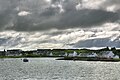
The Ard, Islay, is the peninsula that closes the south of Loch Leòdamais, the inner harbor of Port Ellen. A drowned ridge, it trails off to the southwest in a number of islets and skerries. Its inner coast is occupied by Frederick Crescent. The crest and the outer coast are in their natural state.
Media in category "The Ard, Islay"
The following 18 files are in this category, out of 18 total.
-
 Ard Foreshore - geograph.org.uk - 1151143.jpg 640 × 427; 39 KB
-

-
 Picnic table, Port Ellen - geograph.org.uk - 1012870.jpg 640 × 359; 66 KB
-
 Port Ellen ferry terminal - geograph.org.uk - 1490617.jpg 640 × 416; 40 KB
-
 Port Ellen Ferry Terminal - geograph.org.uk - 470125.jpg 640 × 480; 97 KB
-

-
 Port Ellen of Islay.jpg 400 × 300; 60 KB
-
 Port Ellen Pier - geograph.org.uk - 1150862.jpg 640 × 427; 48 KB
-
 Port Ellen, MV Locheil garden - geograph.org.uk - 919996.jpg 640 × 480; 103 KB
-
 Rubh' a' Chuinnlein - geograph.org.uk - 1414643.jpg 640 × 427; 224 KB
-
 Small Harbour - geograph.org.uk - 15824.jpg 640 × 480; 93 KB
-
 The Ard - geograph.org.uk - 1012894.jpg 640 × 359; 51 KB
-
 The Ard towards Eilean nan Caorach - geograph.org.uk - 1151154.jpg 640 × 427; 34 KB
-

-
 View of Port Ellen from ferry.jpg 4,310 × 2,868; 11.02 MB
-
 Ard grassland - geograph.org.uk - 1149105.jpg 640 × 427; 49 KB
-
 Ard Path - geograph.org.uk - 1151163.jpg 640 × 427; 46 KB
-


