Category:The Albert, Lark Lane
Jump to navigation
Jump to search
| Object location | | View all coordinates using: OpenStreetMap |
|---|
pub in Liverpool, Merseyside, England, UK  | |||||
| Upload media | |||||
| Instance of | |||||
|---|---|---|---|---|---|
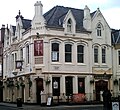
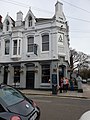
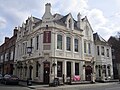
| Location | Liverpool, Merseyside, North West England, England | ||||
| Heritage designation |
| ||||
 | |||||
Media in category "The Albert, Lark Lane"
The following 7 files are in this category, out of 7 total.
-
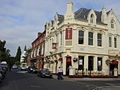 The Albert public house, Lark Lane - geograph.org.uk - 64727.jpg 640 × 480; 60 KB
-
 The Albert, Lark Lane, Liverpool (1).jpg 1,350 × 1,296; 1.06 MB
-
 The Albert, Lark Lane, Liverpool (2).jpg 1,309 × 1,196; 953 KB
-
 The Albert Public House Including Lamp Holders.jpg 3,024 × 4,032; 3.77 MB
-
 The Albert, Lark Lane 2018.jpg 4,167 × 3,145; 4.57 MB
-
 The Albert, Lark Lane, Liverpool (3).JPG 4,320 × 3,240; 2.88 MB
-
 The Albert, Lark Lane, Liverpool (4).JPG 4,320 × 3,240; 2.97 MB

.jpg)
.jpg)

.JPG)
.JPG)