Category:The Albany, Kirkdale
Jump to navigation
Jump to search
| Object location | | View all coordinates using: OpenStreetMap |
|---|
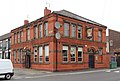
Pub on the corner of Leighton Street and Ruskin Street, Kirkdale, Liverpool.
Media in category "The Albany, Kirkdale"
The following 2 files are in this category, out of 2 total.
-
 The Albany, Kirkdale 2019.jpg 4,485 × 3,039; 8.01 MB
-
 The Albany, Liverpool L4.JPG 4,608 × 3,456; 3.62 MB

