Category:Textile mills in Lancashire
Jump to navigation
Jump to search
Wikimedia category | |||||
| Upload media | |||||
| Instance of | |||||
|---|---|---|---|---|---|
| |||||
Subcategories
This category has the following 12 subcategories, out of 12 total.
B
- Bancroft Mill (38 F)
C
- Centenary Mill, Preston (6 F)
- Coppull Ring Mill (10 F)
G
- Galgate Silk Mill (23 F)
H
- Helmshore Mills Textile Museum (122 F)
I
- Ilex Mill (17 F)
P
- Park Mill, Helmshore (9 F)
Q
T
- Tulketh Mill (12 F)
Media in category "Textile mills in Lancashire"
The following 158 files are in this category, out of 158 total.
-
-

-
 "Union Mill", Sabden - geograph.org.uk - 486435.jpg 640 × 480; 172 KB
-
 "Victoria Mill", Sabden - geograph.org.uk - 486432.jpg 480 × 640; 150 KB
-
 1943-09-25 THE SPHERE 18.jpg 1,996 × 2,224; 2.21 MB
-
 Facit Mill, Market Street, in Facit, Whitworth, Lancashire in 2007.jpg 2,403 × 1,922; 4.11 MB
-
 Facit Mill, Market Street, in Facit, Whitworth Lancashire in 2007.jpg 1,802 × 2,404; 3.6 MB
-
 A derelict Mill at Bamber Bridge (geograph 3332529).jpg 4,317 × 2,873; 7.04 MB
-
 Abbey Mill (geograph 3675179).jpg 3,356 × 2,359; 1.17 MB
-
 Aero Mill - geograph.org.uk - 1226887.jpg 480 × 640; 58 KB
-
 Aero Mill - geograph.org.uk - 1226891.jpg 640 × 480; 61 KB
-
 Albert Mill Chimney - geograph.org.uk - 678476.jpg 480 × 640; 46 KB
-
 Albert Mill, Wyre Street, Padiham (geograph 2612946).jpg 640 × 480; 97 KB
-
 Albion Mill - geograph.org.uk - 1151203.jpg 640 × 480; 58 KB
-
 Albion Mill, Water Street - geograph.org.uk - 1108909.jpg 640 × 480; 87 KB
-
 Alliance Works, Preston (geograph 1995761).jpg 640 × 427; 81 KB
-
 Aqueduct Mill, Preston (geograph 1995843).jpg 640 × 427; 66 KB
-
 Archway at Hardman's Mill - geograph.org.uk - 516814.jpg 640 × 480; 128 KB
-
 Ashfield Mill, Calder Vale Road - geograph.org.uk - 1141965.jpg 640 × 480; 78 KB
-
 Atherton Holme Stacksteads - geograph.org.uk - 462256.jpg 640 × 487; 86 KB
-
 Bacup, Olive Mill (geograph 2487041).jpg 3,456 × 2,304; 4.77 MB
-
 Barnoldswick, Hope Mill (geograph 4458104).jpg 3,778 × 2,626; 1.39 MB
-
 Beech Mill, Bury - geograph.org.uk - 696899.jpg 640 × 427; 59 KB
-
 Belle Vue Mill, Burnley.jpg 640 × 423; 64 KB
-
 Botany Bay - geograph.org.uk - 539600.jpg 640 × 460; 293 KB
-
 Britannia Mill, Darwen.jpg 2,048 × 1,536; 2.46 MB
-
 Britannia Mill, Haslingden - geograph.org.uk - 678480.jpg 640 × 379; 35 KB
-
 Britannia Mill, Haslingden.jpg 480 × 640; 495 KB
-
 Britannia Mills - geograph.org.uk - 81857.jpg 640 × 480; 86 KB
-
 Broadclough Mill - geograph.org.uk - 673868.jpg 480 × 640; 46 KB
-
 Broadclough Mill, Bacup.jpg 640 × 480; 151 KB
-
 Brookhouse Mill, Preston.jpg 640 × 427; 66 KB
-
 Brownside Mill - geograph.org.uk - 678465.jpg 640 × 427; 80 KB
-
 Brownside Mill - geograph.org.uk - 678478.jpg 640 × 427; 107 KB
-
 Burnley Mill Chimneys - geograph.org.uk - 477739.jpg 640 × 322; 73 KB
-
 Canal Mill (Botany Bay), Chorley-geograph-2779832.jpg 640 × 480; 356 KB
-
 Coppull Enterprise Centre - geograph.org.uk - 630967.jpg 640 × 480; 208 KB
-
 Coppull Enterprise Centre - geograph.org.uk - 67432.jpg 640 × 480; 90 KB
-
 Cotton Hall Mill, Darwen.jpg 1,943 × 1,323; 2.22 MB
-
 Cowling Mill.JPG 1,839 × 1,330; 2.86 MB
-
 Crosse Hall Mill.JPG 2,048 × 1,536; 2.5 MB
-
 Darwen Mill, Darwen.jpg 2,048 × 1,536; 2.48 MB
-
 Delivery of wood, Kirk Mills - geograph.org.uk - 934071.jpg 640 × 480; 149 KB
-
 Dolphinholme Mill (1810s).png 839 × 625; 837 KB
-
 Ellenshaw Mill, Darwen.jpg 2,048 × 1,536; 2.42 MB
-
 Engine house for Jubilee Mill - geograph.org.uk - 1243878.jpg 640 × 480; 98 KB
-
 Engine house for Jubilee Mill - geograph.org.uk - 1243899.jpg 640 × 480; 69 KB
-

-
 Engine house, Jubilee Mills, Padiham - geograph.org.uk - 177067.jpg 640 × 428; 73 KB
-
 Facit Mill - geograph.org.uk - 476458.jpg 640 × 480; 147 KB
-
 Facit Mill, Whitworth, Lancashire - geograph.org.uk - 344593.jpg 640 × 481; 104 KB
-
 Factory Lane, Padiham - geograph.org.uk - 890706.jpg 480 × 640; 160 KB
-
 Farholme Mill, Stacksteads (geograph 3478794).jpg 4,320 × 3,240; 4.95 MB
-
 Fire escape for Pentridge Mill - geograph.org.uk - 996896.jpg 480 × 640; 198 KB
-
 Fleetwood Road, Padiham - geograph.org.uk - 1080141.jpg 640 × 480; 95 KB
-
 Gaghills Road - geograph.org.uk - 503874.jpg 640 × 340; 70 KB
-
 Glen Mill - geograph.org.uk - 1431208.jpg 640 × 480; 49 KB
-
 Gorple Mill, Worsthorne - geograph.org.uk - 770601.jpg 640 × 480; 225 KB
-

-
 Gregory's Pine - geograph.org.uk - 694831.jpg 640 × 480; 118 KB
-
 Grimeford Mill.jpg 2,048 × 1,536; 2.62 MB
-
 Grove Mill - geograph.org.uk - 1240720.jpg 640 × 480; 70 KB
-
 Grove Mill, Padiham - geograph.org.uk - 1080142.jpg 640 × 480; 61 KB
-

-
 Higherford Mill, Barrowford - geograph.org.uk - 506509.jpg 480 × 640; 176 KB
-

-
 Hope Mill, Barnoldswick-geograph-4458104.jpg 578 × 355; 133 KB
-
 Horrockses Cotton Mill, Preston.jpg 1,600 × 881; 348 KB
-
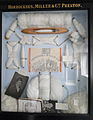 Horrockses display.jpg 2,585 × 3,334; 2.76 MB
-
 Imperial Mill, Blackburn (geograph 2190717).jpg 640 × 428; 102 KB
-

-
 Jubilee Mills, Padiham - geograph.org.uk - 453124.jpg 640 × 428; 51 KB
-
 Kearns Mill - geograph.org.uk - 614966.jpg 640 × 480; 97 KB
-
 Kearns Mill, Boarsgreave - geograph.org.uk - 444685.jpg 640 × 480; 123 KB
-
 Kings Mill - geograph.org.uk - 1218676.jpg 640 × 480; 57 KB
-

-

-
-
 Looking over the Roof of Valley Mills (geograph 2714393).jpg 4,320 × 3,240; 3.73 MB
-
 Lorne St Mill, Darwen.jpg 2,048 × 1,536; 1.42 MB
-
 Manchester Mill, Preston (geograph 1994535).jpg 640 × 427; 61 KB
-
 Meadows Mill - geograph.org.uk - 673876.jpg 640 × 480; 58 KB
-
 Middle Mill, Helmshore.JPG 1,951 × 1,305; 2.01 MB
-

-
 Mill chimney - geograph.org.uk - 1059651.jpg 640 × 480; 203 KB
-
 Mill demolition. - geograph.org.uk - 475121.jpg 640 × 298; 54 KB
-
 Mill Fire Escape. Wales Road. Waterfoot - geograph.org.uk - 503907.jpg 640 × 480; 139 KB
-
 Musbury Mill.JPG 2,048 × 1,536; 2.13 MB
-
 Nelson - Mills at St. Mary's Street - geograph.org.uk - 531012.jpg 533 × 640; 206 KB
-

-
 Old mill - geograph.org.uk - 673050.jpg 640 × 480; 173 KB
-
 Olive Mill, Bacup-geograph-2487041.jpg 640 × 427; 216 KB
-
 Orama Mill - geograph.org.uk - 681295.jpg 640 × 480; 190 KB
-
 Oswaldtwistle - DSC03905.JPG 2,736 × 3,648; 5.59 MB
-
 Oswaldtwistle - DSC03907.JPG 3,648 × 2,736; 3.66 MB
-
 Oxford Mill - geograph.org.uk - 1228362.jpg 640 × 480; 77 KB
-
 Oxford Mill, Harle Syke - geograph.org.uk - 230926.jpg 640 × 480; 209 KB
-
 Pentridge Mill Chimney - geograph.org.uk - 996900.jpg 480 × 640; 171 KB
-
 Pentridge Mill Chimney.jpg 3,000 × 4,000; 3.08 MB
-
 Penwortham Mill (geograph 4781246).jpg 2,816 × 2,112; 2.65 MB
-
 Perseverance Mill - geograph.org.uk - 1243893.jpg 640 × 480; 114 KB
-
 Perseverance Mill - geograph.org.uk - 1243895.jpg 640 × 479; 116 KB
-
 Perseverance Mill - geograph.org.uk - 1243900.jpg 640 × 480; 60 KB
-
 Perseverance Mill, Darwen.jpg 1,882 × 1,449; 1.83 MB
-
 Premier Mill, Darwen.jpg 2,048 × 1,536; 2.14 MB
-
 Preston - Great Bank Street - geograph.org.uk - 529985.jpg 640 × 592; 123 KB
-
 Preston - Shelley Road Mill - geograph.org.uk - 530011.jpg 428 × 640; 225 KB
-
 Preston - Tulketh Mill - geograph.org.uk - 530436.jpg 640 × 320; 179 KB
-
 Preston Aqueduct Mill - geograph.org.uk - 530001.jpg 640 × 617; 295 KB
-
 Preston Aqueduct Street Mill - geograph.org.uk - 529992.jpg 428 × 640; 228 KB
-
 Preston Hanover Street Mill - geograph.org.uk - 529981.jpg 640 × 445; 73 KB
-
 Primrose Mill, Clitheroe (geograph 2918459).jpg 640 × 480; 133 KB
-
 Primrose Mill, Darwen.jpg 2,048 × 1,536; 2.2 MB
-
 Primrose Mill, Harle Syke - geograph.org.uk - 1166005.jpg 640 × 419; 62 KB
-
 Primrose Mill.jpg 2,048 × 1,536; 2.52 MB
-
 Proctor's Works, Burnley.jpg 640 × 427; 63 KB
-
 Progress Mill, Darwen.jpg 1,951 × 1,338; 2.03 MB
-
 Progress Mill.jpg 2,048 × 1,536; 1.26 MB
-
 Queenstreetmill.jpg 424 × 640; 66 KB
-
 Railway Street Stacksteads - geograph.org.uk - 462271.jpg 640 × 480; 129 KB
-
 Rear view of Habergham Street - geograph.org.uk - 756503.jpg 480 × 640; 135 KB
-
 Red Lumb Mill, near Rochdale, Lancashire - geograph.org.uk - 59681.jpg 640 × 480; 122 KB
-

-
 Ribble Street, Padiham (geograph 2612928).jpg 640 × 480; 110 KB
-
 Riverside Mill, Fleetwood Road, Padiham (geograph 2612962).jpg 640 × 480; 114 KB
-

-
 Round the back in Padiham, Lancashire - geograph.org.uk - 626960.jpg 640 × 508; 85 KB
-
 Sherbourn Mill.jpg 2,048 × 1,536; 2.37 MB
-
 Spring Bank Mill, Every Street (geograph 1783314).jpg 640 × 480; 132 KB
-

-

-
 St Lawrence Mill Chimney, Great Harwood (geograph 1942631).jpg 640 × 480; 112 KB
-
 Stockbridge Mill - geograph.org.uk - 1607334.jpg 640 × 480; 83 KB
-
 Stockbridge Mill - geograph.org.uk - 1607353.jpg 640 × 480; 60 KB
-
 Tardy gate mill in snow.jpg 1,632 × 1,224; 820 KB
-
 Tardy Gate Mill.jpg 320 × 264; 50 KB
-
 The Leeds and Liverpool Canal - geograph.org.uk - 679033.jpg 640 × 480; 163 KB
-
 The remains of Crow Nest Mill, Barnoldswick (geograph 5532769).jpg 640 × 477; 135 KB
-
 The road to Botany Bay - geograph.org.uk - 1169011.jpg 640 × 480; 55 KB
-
 The Sun's down, but the Star still shines - geograph.org.uk - 399575.jpg 640 × 487; 347 KB
-
 Tulketh Mill from Blackpool Road - geograph.org.uk - 557632.jpg 640 × 480; 56 KB
-
 Tulketh Mill, Ashton, Preston - geograph.org.uk - 23282 cropped.jpg 346 × 329; 48 KB
-
 Tulketh Mill, Balcarres Street, Preston (geograph 5134955).jpg 640 × 451; 111 KB
-

-
 Victoria Mill chimney.jpg 2,048 × 1,536; 2.11 MB
-
 Victoria Mills - geograph.org.uk - 1240721.jpg 640 × 480; 60 KB
-
 Vine Mill, Oswaldtwistle (geograph 3288292).jpg 480 × 640; 78 KB
-
 Vine Mill, Oswaldtwistle - geograph.org.uk - 709096.jpg 480 × 640; 187 KB
-
 Vyking Mill.jpg 2,048 × 1,536; 1.45 MB
-
 Waterhouse Bridge - geograph.org.uk - 52322.jpg 640 × 480; 193 KB
-
 Whipps Mill, Darwen.jpg 1,857 × 1,244; 1.72 MB
-
 Whitaker Mill, Helmshore.JPG 2,048 × 1,536; 2.4 MB
-
 Whitehall Mill, Darwen.jpg 2,048 × 1,536; 1.98 MB
-
 Woodfold Mill.jpg 2,048 × 1,536; 1.4 MB
-
 Woodnook Mill - geograph.org.uk - 1567585.jpg 640 × 480; 77 KB
-
 Drainpipes, Siberia Mill, Harle Syke - geograph.org.uk - 230930.jpg 640 × 480; 203 KB
-
 Entrance to Oswaldtwistle Mills - geograph.org.uk - 634994.jpg 628 × 470; 147 KB
-

.jpg)


.jpg)
.jpg)


.jpg)


.jpg)
.jpg)


.jpg)
.jpg)


,_Chorley-geograph-2779832.jpg)


.png)


.jpg)


.jpg)
.jpg)


.jpg)

.jpg)


.jpg)


.jpg)


.jpg)
.jpg)


.jpg)


.jpg)


.jpg)


.jpg)


.jpg)


