Category:Texas flora distribution maps
Jump to navigation
Jump to search
Subcategories
This category has the following 5 subcategories, out of 5 total.
Media in category "Texas flora distribution maps"
The following 14 files are in this category, out of 14 total.
-
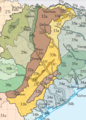
 East Central Texas Ecoregions.gif 573 × 801; 104 KB
-
 East Central Texas Ecoregions.png 573 × 801; 403 KB
-
 Fraxinus texensis range map 2.png 5,121 × 5,121; 336 KB
-
 Juniperus deppeana varieties range map 2.png 3,980 × 3,980; 266 KB
-
 Juniperus pinchotii range map 3.png 2,768 × 2,769; 97 KB
-
 Koeberlinia spinosa range map.png 783 × 816; 100 KB
-
 Platanus occidentalis map.png 636 × 676; 123 KB
-
 Quercus gambelii range map 1.png 3,331 × 3,330; 138 KB
-
 Quercus virginiana range map 1.png 1,800 × 1,800; 86 KB
-
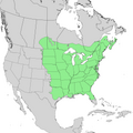 Ulmus americana range map 1.png 7,642 × 7,641; 760 KB
-
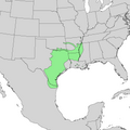 Ulmus crassifolia range map 2.png 4,340 × 4,340; 236 KB
-
 Verbreitungsgebiet von Yucca elata und Subspezies B.jpg 535 × 962; 81 KB
-
 Yucca elata range map.jpg 916 × 708; 206 KB
-
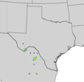 Yucca rostrata range map.png 692 × 668; 40 KB


