Category:Texas State Highway 85
Jump to navigation
Jump to search
 | number: | (eighty-five) |
|---|---|---|
| State highways in Texas: | 65 · 66 · 67 · 68 · 69 · 70 · 71 · 72 · 73 · 74 · 75 · 76 · 77 · 78 · 79 · 80 · 81 · 82 · 83 · 84 · 85 · 86 · 87 · 88 · 89 · 90 · 91 · 92 · 93 · 94 · 95 · 96 · 97 · 98 · 99 · 100 · 101 · 102 · 103 · 104 · 105 |
state highway in Dimmit, Frio, and Atascosa counties in Texas, United States  | |||||
| Upload media | |||||
| Instance of | |||||
|---|---|---|---|---|---|
| Location |
| ||||
| Transport network | |||||
| Owned by |
| ||||
| Maintained by |
| ||||
| Inception |
| ||||
| Length |
| ||||
| Terminus | |||||
| Partially coincident with | |||||
 | |||||
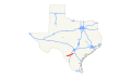
English: Media related to Texas State Highway 85, a 79.926-mile (128.628 km) state highway in Dimmit, Frio, and Atascosa counties in Texas, United States, that connects U.S. Route 83 in Carizzo Springs with Texas State Highway 97 (west of Charlotte).
Media in category "Texas State Highway 85"
The following 6 files are in this category, out of 6 total.
-
 Atascosa County road map.svg 1,180 × 688; 1.17 MB
-
 Old Texas 85.svg 385 × 385; 10 KB
-
 Texas 85 1917.svg 1,600 × 1,600; 17 KB
-
 Texas 85 1935.svg 1,600 × 1,600; 20 KB
-
 Texas 85 map.svg 870 × 516; 383 KB
-
 Texas 85.svg 384 × 384; 9 KB


