Category:Terraced houses in the Metropolitan Borough of Calderdale
Jump to navigation
Jump to search
Subcategories
This category has the following 5 subcategories, out of 5 total.
Media in category "Terraced houses in the Metropolitan Borough of Calderdale"
The following 168 files are in this category, out of 168 total.
-
 "Basharat Minimarket" Stansfield Road Todmorden OL14 5DN - geograph.org.uk - 2108497.jpg 1,632 × 1,024; 412 KB
-
 156-162 Wakefield Road, Lightcliffe.jpg 5,184 × 3,888; 9.03 MB
-
 1–9, Knowl Top, Heptonstall.jpg 4,000 × 3,000; 4.88 MB
-
 66-72 Boy Lane, Wheatley - geograph.org.uk - 1893046.jpg 640 × 508; 141 KB
-
 Approaching Smithy Carr Lane, Brighouse - geograph.org.uk - 5890181.jpg 5,184 × 3,456; 6.9 MB
-
 Ashgrove Avenue - Oxford Lane - geograph.org.uk - 3464380.jpg 640 × 480; 79 KB
-
 Back Queen Street - Stainland Road - geograph.org.uk - 3762312.jpg 640 × 480; 93 KB
-
 Belmont Terrace, Luddenden Foot - geograph.org.uk - 1810653.jpg 640 × 480; 149 KB
-
 Ben Royd Terrace, Jagger Green - geograph.org.uk - 52837.jpg 640 × 480; 134 KB
-
 Benroyd Terrace, north of Jagger Green - geograph.org.uk - 3970089.jpg 1,600 × 1,200; 390 KB
-
 Birkhouse Road - Bailiff Bridge - geograph.org.uk - 507977.jpg 640 × 457; 44 KB
-
 Birkhouse Road - geograph.org.uk - 5467190.jpg 1,024 × 683; 294 KB
-
 Birkhouse Road, Clifton - geograph.org.uk - 259585.jpg 640 × 454; 75 KB
-
 Blackwood Grove - Battinson Road - geograph.org.uk - 1887512.jpg 640 × 480; 69 KB
-
 Booth's Buildings, Bailiff Bridge - geograph.org.uk - 1978502.jpg 2,000 × 1,453; 768 KB
-
-

-
 Braeside - Warley View - geograph.org.uk - 4029471.jpg 640 × 480; 66 KB
-
 Bridge Lane - High Cross Lane - geograph.org.uk - 3083629.jpg 538 × 640; 61 KB
-
 Bridge Terrace, Bradford Road - geograph.org.uk - 507941.jpg 640 × 478; 39 KB
-
 Brook Terrace - geograph.org.uk - 4045767.jpg 2,000 × 1,482; 1.03 MB
-
 Brooklyn Terrace - Half House Lane - geograph.org.uk - 3226118.jpg 640 × 480; 68 KB
-

-
 Burnley Road - geograph.org.uk - 540460.jpg 640 × 436; 51 KB
-

-

-
 Clay Street - Hanson Lane - geograph.org.uk - 1887521.jpg 640 × 480; 56 KB
-
 Clifton Street - Park Road - geograph.org.uk - 4014887.jpg 640 × 480; 76 KB
-
 Clough Lane - viewed from Mill Lane - geograph.org.uk - 1912631.jpg 640 × 480; 61 KB
-
 Co-operative Terrace - Northgate - geograph.org.uk - 1862632.jpg 480 × 640; 83 KB
-
 Copperas Row, Rochdale Road, Greetland - geograph.org.uk - 3810767.jpg 2,048 × 1,368; 756 KB
-
 Coronation Street - Clay House Lane - geograph.org.uk - 3762094.jpg 640 × 480; 83 KB
-
 Cottages, Rochdale Road - geograph.org.uk - 1135465.jpg 640 × 480; 91 KB
-

-
 Cromwell View, Southowram - geograph.org.uk - 1845876.jpg 640 × 480; 164 KB
-
 Doncaster Street - Crossley Hill - geograph.org.uk - 3463759.jpg 640 × 480; 65 KB
-
 Duck Hill, Hebden Bridge - geograph.org.uk - 1231687.jpg 640 × 426; 99 KB
-
 Dyson Street - Lightcliffe Road - geograph.org.uk - 1375043.jpg 640 × 480; 265 KB
-
 Elm Street - Stainland Road - geograph.org.uk - 4265572.jpg 640 × 480; 78 KB
-
 Elm Terrace - geograph.org.uk - 4377905.jpg 4,608 × 3,456; 6.35 MB
-
 Evidence of subsidence - geograph.org.uk - 42898.jpg 640 × 480; 96 KB
-
 Featherbed Close, West Vale - geograph.org.uk - 2231198.jpg 640 × 480; 143 KB
-
 Field Top - Wyke Old Lane - geograph.org.uk - 1386587.jpg 640 × 480; 254 KB
-
 Finkle Street, Luddenden Foot - geograph.org.uk - 1182769.jpg 640 × 480; 110 KB
-
 Firth Street, Rastrick - geograph.org.uk - 2200484.jpg 2,000 × 1,500; 863 KB
-
 Footpath sign at Prospect Terrace, Norland - geograph.org.uk - 4887166.jpg 2,048 × 1,536; 1,008 KB
-
 Four houses, Green Lane, Greetland - geograph.org.uk - 2593389.jpg 2,000 × 1,500; 926 KB
-
 Fox Court, Greetland - geograph.org.uk - 3735422.jpg 2,000 × 1,389; 1.18 MB
-
 Gate, Greetland - geograph.org.uk - 3810846.jpg 2,048 × 1,536; 830 KB
-

-

-
 Glen Terrace - Barfield Road - geograph.org.uk - 2988231.jpg 640 × 480; 85 KB
-
 Greenhouses - geograph.org.uk - 1540329.jpg 640 × 480; 60 KB
-

-
 High Street - geograph.org.uk - 2262251.jpg 640 × 480; 145 KB
-
 Highfield Road, Rastrick (SE133213) - geograph.org.uk - 134415.jpg 640 × 475; 74 KB
-
 Hill Top - St Giles Road - geograph.org.uk - 3226243.jpg 640 × 480; 81 KB
-
 House with Royal Mail letter box, Bank View.Mill Bank - geograph.org.uk - 3795075.jpg 1,492 × 2,000; 913 KB
-
 Houses at Gate Farm, off Scar Bottom Lane - geograph.org.uk - 3372019.jpg 2,000 × 1,395; 756 KB
-
 Houses at Scar Bottom, Greetland - geograph.org.uk - 3810813.jpg 1,974 × 1,449; 980 KB
-

-
 Houses of Holme Street, Wakefield Road - geograph.org.uk - 6014081.jpg 1,024 × 683; 178 KB
-
 Houses of Wakefield Road - geograph.org.uk - 6015925.jpg 1,024 × 683; 189 KB
-
 Houses on Birkhouse Road, Bailiff Bridge - geograph.org.uk - 5162235.jpg 1,600 × 1,065; 472 KB
-
 Houses on Bridge End - geograph.org.uk - 6006264.jpg 1,024 × 683; 160 KB
-
 Houses on Scarr Bottom Road - geograph.org.uk - 2054698.jpg 640 × 480; 161 KB
-
 Houses, Luddenden Foot - geograph.org.uk - 3467715.jpg 640 × 466; 61 KB
-
 Hubberton Green - geograph.org.uk - 1805108.jpg 2,560 × 1,920; 1.08 MB
-

-
 John Street - Clay House Lane - geograph.org.uk - 3762089.jpg 640 × 480; 76 KB
-
 Joseph Avenue - Back Clough - geograph.org.uk - 3080249.jpg 640 × 480; 65 KB
-
 Kell Butts, Wainstalls - geograph.org.uk - 27639.jpg 715 × 536; 120 KB
-

-
 Lane Side, Stainland Road - geograph.org.uk - 3735294.jpg 2,000 × 1,247; 813 KB
-
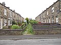
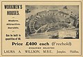 Laura Annie Willson houses in Jumples.jpg 1,024 × 700; 121 KB
-
 Lea Green - geograph.org.uk - 3970070.jpg 1,600 × 1,200; 560 KB
-
 Lily Street - geograph.org.uk - 540453.jpg 640 × 431; 60 KB
-
-
 Lower Shelf - geograph.org.uk - 494698.jpg 640 × 475; 102 KB
-
 Lower Skircoat Green - geograph.org.uk - 1455362.jpg 640 × 480; 97 KB
-
 Lud Hill Top, School Lane, Southowram - geograph.org.uk - 256045.jpg 640 × 482; 105 KB
-
 Luddenden Foot - geograph.org.uk - 4950709.jpg 5,184 × 3,456; 2.02 MB
-
 Lumb Terrace - Lumb Lane - geograph.org.uk - 2040756.jpg 640 × 480; 85 KB
-
 Lumb Terrace, Wainstalls - geograph.org.uk - 1851705.jpg 640 × 463; 68 KB
-
 Manley Street - Bonegate Road - geograph.org.uk - 3400284.jpg 640 × 480; 63 KB
-
 Midgley - geograph.org.uk - 4959681.jpg 5,184 × 3,224; 1.87 MB
-
 Mill - Wainstalls Road - geograph.org.uk - 2041923.jpg 640 × 480; 64 KB
-
 Mitchell Street - Garden Road - geograph.org.uk - 3400262.jpg 640 × 480; 85 KB
-
 Moor End - Moor End Road - geograph.org.uk - 1913348.jpg 640 × 480; 68 KB
-
 Moravian Terrace - Victoria Road - geograph.org.uk - 2988316.jpg 480 × 640; 54 KB
-
 Morley Hall Terrace - geograph.org.uk - 385005.jpg 1,024 × 683; 188 KB
-
 Naylor Street - Battinson Road - geograph.org.uk - 1887501.jpg 640 × 480; 64 KB
-
 New Barton - geograph.org.uk - 387525.jpg 640 × 455; 108 KB
-
 Oak Hill Road, Brighouse - geograph.org.uk - 5162039.jpg 1,600 × 1,065; 557 KB
-
 Osborne Grove - Wakefield Road - geograph.org.uk - 2989014.jpg 640 × 480; 97 KB
-

-

-
 Path to Hulme Street from West Street - geograph.org.uk - 3847807.jpg 1,500 × 2,000; 1.47 MB
-
 Paul Row, Calderbrook - geograph.org.uk - 450479.jpg 640 × 480; 139 KB
-
 Pedimented terrace, Saddleworth Road, Greetland - geograph.org.uk - 2640653.jpg 2,000 × 1,409; 920 KB
-
 Penrose Place (south) - Upper Lane - geograph.org.uk - 3115722.jpg 640 × 480; 92 KB
-
 Prospect Place - Village Street - geograph.org.uk - 2866904.jpg 640 × 480; 65 KB
-
 Queen Street, West Vale - geograph.org.uk - 3735330.jpg 1,916 × 1,365; 721 KB
-
 Rear view of new houses on Grantham Road - geograph.org.uk - 1853231.jpg 640 × 480; 139 KB
-
 Ridge View Road, Rastrick - geograph.org.uk - 2192472.jpg 2,000 × 1,500; 723 KB
-
 Ripley Street - looking towards - geograph.org.uk - 3010274.jpg 640 × 480; 76 KB
-
 Ripley Terrace - Danny Lane - geograph.org.uk - 4608333.jpg 640 × 480; 96 KB
-
 Royal Oak House - geograph.org.uk - 3970120.jpg 1,600 × 1,200; 418 KB
-
 School Lane - off Chapel Lane - geograph.org.uk - 3461102.jpg 480 × 640; 62 KB
-
 Shelf - Wade House Road - geograph.org.uk - 361643.jpg 622 × 416; 40 KB
-
 Shepherds Fold - Upper Lane - geograph.org.uk - 3115731.jpg 640 × 480; 89 KB
-

-
 Silverdale Terrace, off Saddleworth Road - geograph.org.uk - 4305847.jpg 2,000 × 1,500; 1.08 MB
-
 Skircoat Green Dental Practice - geograph.org.uk - 1823941.jpg 640 × 426; 93 KB
-
 Smith House Lane - Wakefield Road - geograph.org.uk - 3010284.jpg 640 × 480; 53 KB
-
 South Lane, Shelf - geograph.org.uk - 209535.jpg 640 × 467; 79 KB
-
 South View - Towngate - geograph.org.uk - 1011433.jpg 640 × 509; 258 KB
-
 Southedge Terrace - Brighouse Road - geograph.org.uk - 2988241.jpg 640 × 480; 66 KB
-

-
 Sowerby Bridge FP114 (Link B) at Hubberton Green Road - geograph.org.uk - 4592307.jpg 2,048 × 1,536; 963 KB
-
 Sowood Hill - New Road, Sowood - geograph.org.uk - 814471.jpg 640 × 430; 57 KB
-

-
 Springfield Terrace - Kirk Lane - geograph.org.uk - 2988179.jpg 640 × 480; 80 KB
-
 St Andrew's Close - Blackmires - geograph.org.uk - 1882196.jpg 640 × 480; 71 KB
-
 St Anne's Place - Beestonley Lane - geograph.org.uk - 4280316.jpg 640 × 480; 66 KB
-
 St Stephen's Street, Copley - geograph.org.uk - 2221679.jpg 640 × 480; 63 KB
-
 Stainland Road - Holywell Green - geograph.org.uk - 811518.jpg 640 × 439; 40 KB
-

-
 Stephen Row - Hough - geograph.org.uk - 3115753.jpg 640 × 480; 85 KB
-
 Syke Lane, Lightcliffe - geograph.org.uk - 6419308.jpg 2,000 × 1,290; 3.24 MB
-
 Terrace and stormy sky, Holywell Green (3907277876).jpg 2,504 × 1,744; 3.56 MB
-

-

-
 Terrace houses, Stainland Road - geograph.org.uk - 3735116.jpg 2,000 × 1,418; 877 KB
-
 Terrace houses, Stainland Road, Greetland - geograph.org.uk - 3816257.jpg 2,000 × 1,500; 1,008 KB
-
 Terrace houses, Stainland Road, Greetland - geograph.org.uk - 3816265.jpg 2,000 × 1,307; 852 KB
-

-
 Terrace of houses in the hamlet of Spring - geograph.org.uk - 3495457.jpg 2,000 × 1,500; 976 KB
-
 Terraced Houses on Mill Lane, Luddenden - geograph.org.uk - 6071484.jpg 5,184 × 3,456; 7.53 MB
-
 Terraced housing - Pinnar Lane - geograph.org.uk - 3353621.jpg 640 × 480; 116 KB
-

-
 The Wellington, Rochdale Road - geograph.org.uk - 1845889.jpg 612 × 460; 167 KB
-
 Thorne Street - looking towards - geograph.org.uk - 4265574.jpg 640 × 480; 74 KB
-
 Thorne Street - Stainland Road - geograph.org.uk - 4265568.jpg 640 × 480; 89 KB
-
 Towngate, Hipperholme - geograph.org.uk - 492130.jpg 640 × 476; 88 KB
-
 Triangle - 4-storey terrace on Rochdale Road - geograph.org.uk - 3694652.jpg 1,024 × 761; 234 KB
-
 Victoria Terrace - Victoria Road - geograph.org.uk - 2989001.jpg 640 × 480; 77 KB
-
 View of Goit Side from Booth Hill - geograph.org.uk - 4045890.jpg 2,000 × 1,500; 1.42 MB
-

-
 Village Street, Norwood Green - geograph.org.uk - 5163083.jpg 1,600 × 1,065; 664 KB
-
 Walker Bridge - geograph.org.uk - 3128841.jpg 2,000 × 1,500; 878 KB
-
 Waterloo Terrace, Warley - geograph.org.uk - 2713389.jpg 640 × 480; 115 KB
-
 Wells Terrace, Norwood Green - geograph.org.uk - 1287042.jpg 640 × 480; 71 KB
-

-
 West Street, Stone Chair - geograph.org.uk - 386576.jpg 473 × 640; 120 KB
-
 Westfield - Wakefield Road - geograph.org.uk - 2989012.jpg 640 × 480; 78 KB
-
 Westfield - Wakefield Road - geograph.org.uk - 2989013.jpg 640 × 480; 103 KB
-
 Westward Ho - Churn Milk Lane - geograph.org.uk - 1882179.jpg 640 × 480; 90 KB
-
 White Windows, Sowerby - geograph.org.uk - 2275221.jpg 2,000 × 1,518; 787 KB
-
 Whiterose Terrace, Bradshaw Lane - geograph.org.uk - 2245216.jpg 640 × 480; 210 KB
-
 Wine Tavern Road - Hubberton Green - geograph.org.uk - 823835.jpg 640 × 510; 81 KB
-
 Withinfields - Law Lane - geograph.org.uk - 1011950.jpg 640 × 431; 205 KB
-
 Woodbrook Avenue, Mixenden - geograph.org.uk - 2713335.jpg 640 × 480; 77 KB
-

-
 ^100 Thornhill Road - geograph.org.uk - 6006616.jpg 683 × 1,024; 178 KB
-
 ^16 High Street - geograph.org.uk - 6011119.jpg 683 × 1,024; 150 KB
-
 ^19 Gooder Lane, 'Trevethoe' - geograph.org.uk - 6005971.jpg 683 × 1,024; 164 KB
-
 ^27 Rayner Road - geograph.org.uk - 6021823.jpg 683 × 1,024; 208 KB


_-_geograph.org.uk_-_134417.jpg)


_-_geograph.org.uk_-_134415.jpg)


_-_Upper_Lane_-_geograph.org.uk_-_3115722.jpg)


_at_Hubberton_Green_Road_-_geograph.org.uk_-_4592307.jpg)


.jpg)


,_Clifton_-_geograph.org.uk_-_1211497.jpg)


