Category:Temple Hill
Jump to navigation
Jump to search
mountain in Hong Kong  | |||||
| Upload media | |||||
| Instance of | |||||
|---|---|---|---|---|---|
| Location |
| ||||
| Elevation above sea level |
| ||||
 | |||||
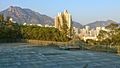
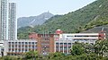
English: Temple Hill, also known as Tsz Wan Shan, is a hill between New Kowloon and the New Territories, Hong Kong. It peaks at 488 m. Beneath its south side is the residential area of Tsz Wan Shan and Buddhist temples. Its north are villages the New Territories. Between the hill and Unicorn Ridge is Sha Tin Pass. The summit of the hill is located within Sha Tin District.
中文:慈雲山
Subcategories
This category has the following 2 subcategories, out of 2 total.
S
V
- Views from Temple Hill (6 F)
Media in category "Temple Hill"
The following 50 files are in this category, out of 50 total.
-
 10,000 Buddhas Monastery IMG 4869.JPG 5,184 × 3,456; 5.2 MB
-
 13-08-08-hongkong-by-RalfR-109.jpg 4,288 × 2,848; 6.8 MB
-
 Aerial view of Kowloon Walled City in Hong Kong on 1989-03-27.jpg 711 × 514; 186 KB
-
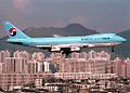 Boeing 747-230F, Korean Air Cargo AN0288301.jpg 1,024 × 734; 463 KB
-
 Choi Hung Estate 2012.jpg 4,000 × 3,000; 4.17 MB
-
 Diamond Hill, Hong Kong - panoramio (13).jpg 3,840 × 2,160; 3.22 MB
-
 Diamond Hill, Hong Kong - panoramio (4).jpg 4,000 × 2,250; 2.01 MB
-
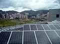 Electrical and Mechanical Services Department Headquarters Photovoltaics.jpg 1,574 × 1,168; 1.8 MB
-
 Fireboat Elite.JPG 3,888 × 2,592; 3.44 MB
-
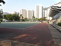 Football pitch of Ping Shek Playground.JPG 3,648 × 2,736; 2.12 MB
-
 FuShanEstate.jpg 1,424 × 1,068; 259 KB
-
 GENERAL SECSHL SITE CHR PS 2010.jpg 3,648 × 2,736; 4.72 MB
-
 GENERAL VIEW CHOI WAN EST 2008.jpg 1,200 × 900; 384 KB
-
 Hammer Hill, Hong Kong - panoramio (1).jpg 4,000 × 2,250; 2.55 MB
-
 Hammer Hill, Hong Kong - panoramio.jpg 4,000 × 2,250; 2.32 MB
-
 HK Diamond Hill Buildings.jpg 2,816 × 2,112; 4.16 MB
-
 HK TakOiSecondarySchool.JPG 1,424 × 1,068; 231 KB
-
 Hong Kong Nan Lian Garden IMG 4885.JPG 5,184 × 3,456; 2.46 MB
-
 Hong Kong San Po Kong Sheung Hei Street.JPG 4,000 × 3,000; 4.37 MB
-
 Hung Hom Bay 201408.jpg 2,816 × 1,456; 2.79 MB
-
 Kai Chuen Court Site 202012.jpg 3,768 × 2,826; 6.79 MB
-
 Kccseaview(1).jpg 2,688 × 2,016; 3.49 MB
-
 Kowloon City 2008.jpg 2,272 × 1,704; 3.43 MB
-
 Kowloon Rock.jpg 4,160 × 2,340; 2.56 MB
-
 Kowloon Tsai, Hong Kong - panoramio (42).jpg 4,000 × 2,250; 2.31 MB
-
 Kwun Yum Temple, Tsz Wan Shan 02.jpg 4,160 × 3,120; 4.37 MB
-
 Kwun Yum Temple, Tsz Wan Shan 04.jpg 4,160 × 3,120; 3.52 MB
-
 Lion Rock and Kowloon Peak.jpg 3,264 × 1,836; 1.42 MB
-
 People sit in rock on Lion Rocks.jpg 5,472 × 3,648; 1.55 MB
-
 Ping Shek Playground.JPG 3,648 × 2,736; 1.83 MB
-
 Po Kong Village Road Park 2018.jpg 1,600 × 1,200; 2.15 MB
-
 San Po Kong 2010.jpg 2,789 × 2,073; 5.06 MB
-
 San Po Kong, Hong Kong - panoramio (11).jpg 4,000 × 2,250; 2.43 MB
-
 San Po Kong, Hong Kong - panoramio (8).jpg 4,000 × 2,250; 2.21 MB
-
 San Po Kong, Hong Kong - panoramio (9).jpg 4,000 × 2,250; 2.72 MB
-
 Sha Tin Pass, Hong Kong - panoramio (2).jpg 4,000 × 2,250; 2.89 MB
-
 Shui Chuen O 2016.jpg 1,600 × 1,200; 1.45 MB
-
 Temple Hill 1.jpg 2,048 × 1,536; 829 KB
-
 The Latitude 201707.jpg 964 × 1,500; 1.08 MB
-
 Tsz Ching Estate (deep blue sky).jpg 2,269 × 1,500; 3.2 MB
-
 Tsz Wan Shan, Hong Kong - panoramio (8).jpg 4,000 × 2,250; 2.41 MB
-
 Tvb tws tower.JPG 929 × 503; 264 KB
-
 Tws-transmission-tower-9.jpg 1,700 × 1,190; 487 KB
-
 Views from Checkerboard Hill 05.jpg 4,160 × 3,120; 4.33 MB
-
 Views from West Buffalo Hill 01.jpg 4,000 × 3,000; 3.51 MB
-
 九龍仔運動場 - panoramio.jpg 4,000 × 2,250; 2.04 MB
-
 德望中學 - panoramio.jpg 3,072 × 1,728; 3.23 MB
-
 樂富 - panoramio.jpg 2,400 × 1,350; 599 KB
-
 民生書院 - panoramio.jpg 4,000 × 2,250; 1.69 MB
-
 聖博德學校 - panoramio.jpg 4,000 × 2,250; 2.46 MB


.jpg)
.jpg)


.jpg)


.jpg)


.jpg)


.jpg)
.jpg)
.jpg)
.jpg)


.jpg)
.jpg)


