Category:Telugu-language maps
Jump to navigation
Jump to search
Subcategories
This category has the following 2 subcategories, out of 2 total.
T
Media in category "Telugu-language maps"
The following 14 files are in this category, out of 14 total.
-
 Andhra Pradesh districts - Telugu.svg 746 × 620; 1.59 MB
-
 Bay of Bengal (te).png 328 × 335; 176 KB
-
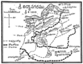
 LanguageMap-AndhrulaCharitramuPart1-p327.png 566 × 769; 265 KB
-
Locate a place on OpenStreetMap via Telugu Wikipedia.ogg 1 min 12 s, 720 × 1,280; 10.56 MB
-
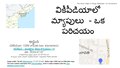
 Locator map examples in Telugu Wikipedia.png 1,118 × 665; 577 KB
-
 Map of Vijayanagara.png 1,084 × 830; 719 KB
-
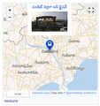 Mapframe usage example on telugu wikipedia.png 496 × 528; 235 KB
-
 Maps in Telugu Wikipedia - An Introduction.pdf 1,500 × 843, 31 pages; 3.63 MB
-
 Prakasam district places.png 859 × 652; 306 KB
-
 Telangana State Telugu Map.svg 637 × 602; 1.85 MB
-
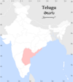 Teluguspeakers.png 1,000 × 1,138; 132 KB
-
 Text based AP Revenue village infobox in Telugu Wikipedia.png 244 × 463; 45 KB
-
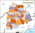 TG-districts-te.svg 667 × 630; 2.7 MB
-
 Wikidata based AP Revenue Village infobox in Telugu Wikipedia.png 316 × 797; 132 KB

.png)


