Category:Tank footbridge, Binsey
Jump to navigation
Jump to search
footbridge in Binsey, UK  | |||||
| Upload media | |||||
| Instance of | |||||
|---|---|---|---|---|---|
| Location |
| ||||
| Crosses | |||||
| Inception |
| ||||
 | |||||
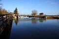
Still on many maps as 'Tank Bridge', this robust bailey bridge is heavily narrowed on its eastern approach so four-wheeled vehicles cannot, as stated on its signs is forbidden, use this main-waters-of-the-Thames crossing point. Further channels are to the east and even far west such is the complexity of the river locally. The bridge acts as a simple east-west pedestrian crossing, with Rainbow Bridge, Binsey (visible together from the Thames Path to the south). It connects Port Meadow in the City of Oxford with Binsey (of historical note its manor of Medley) in the surrounding county.
Media in category "Tank footbridge, Binsey"
The following 5 files are in this category, out of 5 total.
-
 Bailey Bridge - geograph.org.uk - 5266419.jpg 4,000 × 2,666; 6.96 MB
-
 Bridge over Fiddler's Island Stream - geograph.org.uk - 1758528.jpg 1,500 × 1,000; 256 KB
-
 River Thames at Medley, Binsey - geograph.org.uk - 530958.jpg 640 × 602; 134 KB
-
-
 The Thames Path footbridge from Fiddler's Island - geograph.org.uk - 1760198.jpg 1,500 × 1,000; 157 KB


