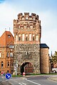
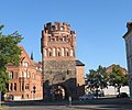
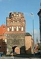
Category:Tangermünder Tor (Stendal)
Jump to navigation
Jump to search
| Object location | | View all coordinates using: OpenStreetMap |
|---|
 | |||||
| Upload media | |||||
| Instance of | |||||
|---|---|---|---|---|---|
| Location | Stendal, Stendal District, Saxony-Anhalt, Germany | ||||
| Heritage designation | |||||
 | |||||
This is the category of the Saxony-Anhalt Kulturdenkmal (cultural heritage monument) with the ID 09475831 (Wikidata)
|
Media in category "Tangermünder Tor (Stendal)"
The following 17 files are in this category, out of 17 total.
-
 Bundesarchiv B 145 Bild-F088955-0037, Stendal, Stadttor.jpg 800 × 507; 65 KB
-
 Paul Wilhelm Meyerheim Uenglinger Tor Stendal.jpg 2,907 × 3,764; 3.56 MB
-
 SDL Tangermünder Tor 761.JPG 3,000 × 4,000; 6.81 MB
-
 Stendal 2015 by Rainhard Triltsch 132.jpg 2,752 × 4,728; 5.56 MB
-
 Stendal 2015 by Rainhard Triltsch 133.jpg 1,560 × 2,232; 946 KB
-
 Stendal Tangermuender Tor-03.jpg 3,410 × 5,115; 2.75 MB
-
 Stendal Tangermünder Tor Heimatfreund 1896.jpg 4,312 × 2,128; 1.7 MB
-
 Stendal Tangermünder Tor-01.jpg 3,648 × 5,472; 2.37 MB
-
 Stendal Tangermünder Tor-02.jpg 3,057 × 4,586; 2.59 MB
-
 Stendal, das Tangermünder Tor.jpg 3,191 × 5,185; 4.46 MB
-
 Stendal, Sachsen-Anhalt - Tangermünder Tor (Zeno Ansichtskarten).jpg 2,134 × 1,341; 278 KB
-
 StendalTangermünderTor2022.jpg 2,565 × 2,135; 1.05 MB
-
 Tangemünder Tor in Stendal.jpg 1,147 × 880; 365 KB
-
 Tangermünder Tor Stendal 2012.JPG 2,592 × 3,872; 2.41 MB
-
 Tangermündertor I.jpg 1,796 × 1,184; 260 KB
-
 Tangermündertor II.jpg 1,797 × 1,186; 416 KB
-
 Tangermündertor peng1.jpg 403 × 570; 133 KB


.jpg)


