Category:TIF versions of Bromley maps of Manhattan published in 1911
Jump to navigation
Jump to search
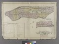
Maps from: Bromley, George W. and Walter S. Atlas of the City of New York Borough of Mahattan. (Philadelphia: G. W. Bromley and Co., 1911). Comprising title page, two-page street index, and double-page outline and index map, plus 50 detailed maps (double-page plates) of which 31 are missing from this category.
Online at The New York Public Library Digital Collection website, Atlas of the city of New York….
Media in category "TIF versions of Bromley maps of Manhattan published in 1911"
The following 23 files are in this category, out of 23 total.
-

-
 STREET INDEX. Arlington Square - Hewitt Avenue. NYPL1512202.tiff 5,248 × 6,299; 94.6 MB
-
 Street Index. High Bridge Terrace. - York St. NYPL1512203.tiff 5,248 × 6,299; 94.6 MB
-
-

-

-

-

-

-

-

-

-

-

-

-

-

-

-

-

-

-

-
