Category:Türmlihus (Kefikon)
Jump to navigation
Jump to search
| Object location | | View all coordinates using: OpenStreetMap |
|---|
|
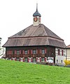
This is a category about a cultural property of regional significance in Switzerland with KGS number 13720
|
 | |||||
| Upload media | |||||
| Instance of | |||||
|---|---|---|---|---|---|
| Part of | |||||
| Location | |||||
| Street address |
| ||||
| Heritage designation |
| ||||
 | |||||
Media in category "Türmlihus (Kefikon)"
The following 3 files are in this category, out of 3 total.
-
 Ehemaliger Fabrikantenbau "Zur Blume - Zum Frieden" in Kefikon.jpg 3,939 × 2,462; 5.72 MB
-
 Türmlihus in Kefikon (Gachnang).jpg 3,120 × 3,744; 7.37 MB
-
 Türmlihus, Dorfstr. 19 in Kefikon TG.jpg 3,120 × 4,001; 8.33 MB

.jpg)