Category:Tête aux Chamois
Jump to navigation
Jump to search
| Object location | | View all coordinates using: OpenStreetMap |
|---|
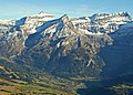
mountain in Switzerland | |||||
| Upload media | |||||
| Instance of | |||||
|---|---|---|---|---|---|
| Location |
| ||||
| Mountain range | |||||
| Topographic prominence |
| ||||
| Elevation above sea level |
| ||||
 | |||||
Subcategories
This category has the following 4 subcategories, out of 4 total.
C
T
Media in category "Tête aux Chamois"
The following 7 files are in this category, out of 7 total.
-
 1 1 tete aux chamois april 23.jpg 1,613 × 1,210; 481 KB
-
 CH-NB Photoglob-Wehrli EAD-WEHR-4771-B.tif 7,353 × 5,463, 2 pages; 76.68 MB
-
 ColduPillon0001.jpg 640 × 480; 53 KB
-
 Diablerets-Poste.jpg 800 × 1,200; 1.02 MB
-
 Diablerets0001.jpg 586 × 419; 103 KB
-
 Lac Retaud.jpg 4,000 × 2,888; 8.18 MB
-
 גלאסייר 3000.JPG 4,000 × 3,000; 7.7 MB


