Category:Swinford, Leicestershire
Jump to navigation
Jump to search
Cymraeg: Pentref a chymuned yn Lloegr ydy Swinford, Swydd Gaerlŷr; saif yn .
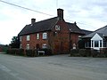
English: Swinford is a nucleated village and civil parish in the Harborough district of the English county of Leicestershire. It used to be on the former A427, which led under the M1, to Catthorpe. The parish church is All Saints, a 12th-century Norman rebuilding of an earlier Saxon church with a 14th-century square bell tower. The local pub is The Chequers on the High Street, formerly known as Chequer Inn.
Polski: Swinford – wieś w Anglii, w hrabstwie Leicestershire, w dystrykcie Harborough. Leży 25 km na południe od miasta Leicester i 123 km na północny zachód od Londynu.

village and civil parish in Leicestershire, United Kingdom | |||||
| Upload media | |||||
| Instance of | |||||
|---|---|---|---|---|---|
| Location | Harborough, Leicestershire, East Midlands, England | ||||
| Population |
| ||||
| Area |
| ||||
| official website | |||||
 | |||||
Subcategories
This category has only the following subcategory.
S
Media in category "Swinford, Leicestershire"
The following 159 files are in this category, out of 159 total.
-
 A14 Closed Layby - geograph.org.uk - 1756923.jpg 1,024 × 768; 125 KB
-
 A14 eastbound south of Swinford - geograph.org.uk - 5078342.jpg 640 × 481; 52 KB
-
 A14 from M1-M6 roundabout - geograph.org.uk - 2071376.jpg 640 × 480; 64 KB
-

-
 Across fields to Catthorpe Interchange - geograph.org.uk - 1778611.jpg 1,014 × 761; 134 KB
-

-
 Base of turbine 01 at Swinford Wind Farm - geograph.org.uk - 3429238.jpg 4,000 × 3,000; 3.25 MB
-
 Bridleways beside River Avon - geograph.org.uk - 1778737.jpg 761 × 1,014; 171 KB
-
 Broken footbridge, south of Swinford - geograph.org.uk - 1756927.jpg 768 × 1,024; 283 KB
-
 Catthorpe Interchange - geograph.org.uk - 2012792.jpg 4,224 × 3,168; 6.12 MB
-
 Catthorpe Interchange - geograph.org.uk - 4352707.jpg 1,600 × 1,200; 305 KB
-
 Catthorpe Interchange - geograph.org.uk - 4352725.jpg 1,600 × 1,200; 452 KB
-
 Catthorpe Interchange - geograph.org.uk - 4711831.jpg 640 × 426; 41 KB
-
 Catthorpe Interchange - geograph.org.uk - 5719036.jpg 1,280 × 851; 283 KB
-

-

-
 Catthorpe-M6 Motorway - geograph.org.uk - 4352753.jpg 1,600 × 975; 402 KB
-
 Chequers public house, Swinford - geograph.org.uk - 2804376.jpg 800 × 600; 100 KB
-
 Chequers public house, Swinford - geograph.org.uk - 2804378.jpg 600 × 800; 79 KB
-
 Chequers Swinford.jpg 2,215 × 1,640; 649 KB
-
 Daffodils along Rugby Road in Swinford - geograph.org.uk - 4760654.jpg 800 × 543; 177 KB
-
 Denyers Barn near Swinford - geograph.org.uk - 3429257.jpg 2,801 × 1,923; 1.64 MB
-
 Denyers Barn near Swinford - geograph.org.uk - 3429265.jpg 2,429 × 1,835; 1.44 MB
-
 Dwellings in Swinford - geograph.org.uk - 4619937.jpg 800 × 531; 111 KB
-

-

-
 Electricity pylon near Rugby Road - geograph.org.uk - 3430777.jpg 3,213 × 2,549; 2.57 MB
-
 End of the M6, Catthorpe - geograph.org.uk - 1818447.jpg 640 × 480; 152 KB
-
 Farm buildings along Lutterworth Road - geograph.org.uk - 3429183.jpg 3,468 × 2,532; 2.75 MB
-
 Field footpaths, Swinford - geograph.org.uk - 1756879.jpg 1,024 × 768; 286 KB
-
 Footbridge over the M1 - geograph.org.uk - 4689726.jpg 640 × 413; 29 KB
-
 Footpath from fields, Swinford - geograph.org.uk - 1756935.jpg 1,024 × 768; 178 KB
-
 Footpath junction, outskirts of Swinford - geograph.org.uk - 1756933.jpg 1,024 × 768; 140 KB
-
 Gate and footpath to Swinford Wind Farm - geograph.org.uk - 3429242.jpg 3,477 × 2,572; 2.79 MB
-
 Gated approach, Tomley Hall Farm - geograph.org.uk - 1775122.jpg 1,024 × 768; 159 KB
-
 Hay bales near Swinford Wind Farm - geograph.org.uk - 3429262.jpg 3,550 × 2,665; 2.63 MB
-
 Hello A14 - geograph.org.uk - 1818473.jpg 640 × 480; 92 KB
-
 High Street in Swinford - geograph.org.uk - 3429272.jpg 4,000 × 3,000; 2.34 MB
-
 High Street, Swinford - geograph.org.uk - 5719065.jpg 1,280 × 851; 375 KB
-
 Horse next to Stanford Road - geograph.org.uk - 4760688.jpg 800 × 610; 108 KB
-
 House and church, Swinford - geograph.org.uk - 4619941.jpg 800 × 531; 117 KB
-
 In the Catthorpe Interchange, M1 - geograph.org.uk - 4689746.jpg 640 × 338; 28 KB
-
 Kilworth Road Farm in Swinford - geograph.org.uk - 3430771.jpg 3,315 × 2,168; 2.26 MB
-
 Kilworth Road in Swinford - geograph.org.uk - 3429273.jpg 4,000 × 3,000; 3.47 MB
-
 Kilworth Road in Swinford - geograph.org.uk - 3430774.jpg 2,701 × 2,284; 1.83 MB
-

-
 Layby on the A14 - geograph.org.uk - 3813934.jpg 640 × 480; 295 KB
-
 Lilbourne Lane, Swinford - geograph.org.uk - 1756941.jpg 1,024 × 768; 121 KB
-
 Lutterworth Road in Swinford - geograph.org.uk - 3429270.jpg 2,804 × 1,898; 1.59 MB
-
 M1 junction 19 - geograph.org.uk - 6527300.jpg 3,648 × 2,432; 2.67 MB
-
 M1 Motorway Southbound - geograph.org.uk - 3166613.jpg 640 × 480; 68 KB
-

-
 M1 southbound - geograph.org.uk - 3586455.jpg 640 × 444; 40 KB
-
 M1 southbound - geograph.org.uk - 3586463.jpg 640 × 471; 33 KB
-
 M1 southbound - geograph.org.uk - 3586465.jpg 640 × 471; 34 KB
-
 Meandering River Avon, A14 - geograph.org.uk - 1778624.jpg 1,014 × 761; 204 KB
-
 Meandering River Avon, Swinford - geograph.org.uk - 1778656.jpg 1,014 × 761; 153 KB
-
 Modern housing, Swinford - geograph.org.uk - 1756866.jpg 1,024 × 768; 126 KB
-
 New building and track at Swinford Corner - geograph.org.uk - 3429172.jpg 3,904 × 2,738; 3.19 MB
-
 North Street, Swinford - geograph.org.uk - 3848333.jpg 1,600 × 808; 346 KB
-

-
 Old Milepost - geograph.org.uk - 2999008.jpg 768 × 1,024; 321 KB
-
 Overbridge, Catthorpe Interchange - geograph.org.uk - 4711833.jpg 640 × 410; 36 KB
-

-
 River Avon and bridge - geograph.org.uk - 1778629.jpg 1,014 × 761; 209 KB
-
 River Avon and bridleway - geograph.org.uk - 1778719.jpg 1,014 × 761; 195 KB
-
 River Avon and bridleway, A14 - geograph.org.uk - 1778756.jpg 1,014 × 761; 103 KB
-
 Roadworks, M1, Southbound - geograph.org.uk - 4689742.jpg 640 × 289; 28 KB
-

-
 Rugby Road towards South Kilworth - geograph.org.uk - 3430779.jpg 4,000 × 3,000; 4.61 MB
-
 Rugby Road, Swinford - geograph.org.uk - 2804366.jpg 800 × 600; 156 KB
-
 Shalwell Road Bridge, M1 - geograph.org.uk - 4711827.jpg 640 × 426; 45 KB
-
 Shawell Road bridge over the M1 - geograph.org.uk - 4304055.jpg 640 × 413; 60 KB
-
 Shawell Road Bridge, M1 - geograph.org.uk - 4689728.jpg 640 × 383; 30 KB
-
 Shawell Road, bridleway - geograph.org.uk - 1775056.jpg 1,014 × 761; 149 KB
-
 Sheep and pasture along Kilworth Road - geograph.org.uk - 3430772.jpg 3,528 × 2,594; 2.6 MB
-
 Sheep pasture near Swinford Wind Farm - geograph.org.uk - 3429268.jpg 3,240 × 2,212; 2.12 MB
-
 Slip road on the Catthorpe Interchange - geograph.org.uk - 4517323.jpg 2,915 × 1,550; 1.94 MB
-
 Slip road to M6 northbound from A14 - geograph.org.uk - 2071366.jpg 640 × 465; 76 KB
-
 Small pond in a wood - geograph.org.uk - 3429254.jpg 4,000 × 3,000; 3.38 MB
-
 South along Lutterworth Road - geograph.org.uk - 3429248.jpg 4,000 × 3,000; 3.7 MB
-
 Stanford Road, Swinford - geograph.org.uk - 1756842.jpg 1,024 × 768; 174 KB
-
 Stanford Road, Swinford - geograph.org.uk - 3750042.jpg 1,600 × 1,064; 297 KB
-
 Stanford Road, Swinford - geograph.org.uk - 3750043.jpg 1,600 × 1,064; 488 KB
-
 Stile and field to Swinford Road - geograph.org.uk - 1775550.jpg 768 × 1,024; 200 KB
-
 Stile and footpath, A14 - geograph.org.uk - 1756924.jpg 768 × 1,024; 202 KB
-
 Stile and gate, Swinford - geograph.org.uk - 1756874.jpg 1,024 × 768; 167 KB
-
 Swinford - Church Walk - geograph.org.uk - 2757390.jpg 640 × 480; 69 KB
-
 Swinford Farmland - geograph.org.uk - 4352771.jpg 1,600 × 1,200; 528 KB
-
 Swinford High Street - geograph.org.uk - 1756835.jpg 1,024 × 768; 130 KB
-
 Swinford High Street - geograph.org.uk - 594144.jpg 640 × 413; 106 KB
-
 Swinford Road at Swinford Corner - geograph.org.uk - 3429155.jpg 1,787 × 1,242; 723 KB
-
 Swinford Road near Swinford Corner - geograph.org.uk - 3432305.jpg 4,000 × 3,000; 3.53 MB
-
 Swinford Village Green - geograph.org.uk - 1756847.jpg 1,024 × 768; 178 KB
-
 Swinford Village Hall - geograph.org.uk - 2755463.jpg 640 × 480; 57 KB
-
 Swinford Village Hall - geograph.org.uk - 4619931.jpg 1,024 × 680; 227 KB
-
 Swinford Wind Farm - geograph.org.uk - 5718818.jpg 1,280 × 851; 333 KB
-
 Swinford, Rugby Road - geograph.org.uk - 1756850.jpg 1,024 × 768; 149 KB
-
 Swinford-High Street - geograph.org.uk - 2766158.jpg 640 × 480; 72 KB
-
 Swinford-North Street - geograph.org.uk - 2756856.jpg 640 × 480; 64 KB
-
 Swinford-Rugby Road - geograph.org.uk - 2756867.jpg 640 × 480; 57 KB
-
 Swinford-Rugby Road - geograph.org.uk - 2757435.jpg 640 × 513; 67 KB
-
 Swinford-School Lane - geograph.org.uk - 2755478.jpg 640 × 547; 55 KB
-
 Swinford-Stanford Road - geograph.org.uk - 2756842.jpg 640 × 422; 117 KB
-
 Swinford-Stanford Road - geograph.org.uk - 2766167.jpg 640 × 480; 76 KB
-
 Swinford-The Chequers - geograph.org.uk - 2757470.jpg 640 × 480; 72 KB
-
 The A14 passes under the M1 - geograph.org.uk - 594152.jpg 640 × 424; 113 KB
-
 The Catthorpe Bottleneck - geograph.org.uk - 3577717.jpg 640 × 480; 66 KB
-
 The centre of Swinford - geograph.org.uk - 594141.jpg 640 × 588; 110 KB
-
 The Limes on Rugby Road in Swinford - geograph.org.uk - 4760663.jpg 800 × 514; 100 KB
-
 The M1 heading north - geograph.org.uk - 6301004.jpg 2,700 × 2,025; 331 KB
-
 The M1 heading north - geograph.org.uk - 6301007.jpg 2,700 × 2,025; 311 KB
-
 The M1 heading north - geograph.org.uk - 6301008.jpg 2,700 × 2,025; 365 KB
-
 The M1 runs under the Catthorpe Junction - geograph.org.uk - 6301006.jpg 2,700 × 2,025; 256 KB
-
 The village of Swinford - geograph.org.uk - 4619945.jpg 800 × 531; 126 KB
-
 To Harboro 12 - geograph.org.uk - 2999018.jpg 1,024 × 768; 262 KB
-
 Towards Birmingham - geograph.org.uk - 3349782.jpg 640 × 508; 41 KB
-
 Towards Old Barn Farm - geograph.org.uk - 3349783.jpg 640 × 479; 57 KB
-
 Track and footpath across Swinford Wind Farm - geograph.org.uk - 3429191.jpg 3,991 × 2,846; 3.26 MB
-
 Turbine 01 at Swinford Wind Farm - geograph.org.uk - 3429204.jpg 3,078 × 2,238; 1.62 MB
-
 Turbine 01 at Swinford Wind Farm - geograph.org.uk - 3429235.jpg 3,000 × 4,000; 2.64 MB
-
 Turbine 01 nacelle, hub and blades - geograph.org.uk - 3429208.jpg 3,242 × 2,971; 2.44 MB
-
 Turbines 2 and 3 at Swinford Wind Farm - geograph.org.uk - 3429231.jpg 3,347 × 2,675; 2.52 MB
-
 View towards Denyers Barn - geograph.org.uk - 5719086.jpg 1,280 × 851; 416 KB
-
 Welcome to Leicestershire - geograph.org.uk - 2080355.jpg 640 × 480; 68 KB
-
 Welcome to Swinford - geograph.org.uk - 594138.jpg 640 × 459; 145 KB
-
 Works at the Catthorpe interchange - geograph.org.uk - 4819979.jpg 1,600 × 1,020; 271 KB
-
 Works at the Catthorpe interchange - geograph.org.uk - 4819984.jpg 1,600 × 1,074; 290 KB
-
 A rickety barn along Rugby Road - geograph.org.uk - 597345.jpg 640 × 424; 77 KB
-
 Autumn in south Leicestershire - geograph.org.uk - 605870.jpg 640 × 462; 117 KB
-
 Country lane in south Leicestershire - geograph.org.uk - 605877.jpg 640 × 470; 127 KB
-
 Countryside north of Rugby Road - geograph.org.uk - 597339.jpg 640 × 426; 74 KB
-
 Farm buildings off Rugby Road - geograph.org.uk - 597358.jpg 640 × 401; 70 KB
-
 Farmland near Swinford - geograph.org.uk - 594135.jpg 640 × 388; 103 KB
-
 Farmland near Swinford Covert - geograph.org.uk - 592918.jpg 436 × 640; 113 KB
-
 Farmland off Rugby Road, Leicestershire - geograph.org.uk - 597324.jpg 640 × 514; 101 KB
-
 Kibworth Road, Leicestershire - geograph.org.uk - 597313.jpg 640 × 440; 70 KB
-
 London Lodge - geograph.org.uk - 605869.jpg 640 × 432; 75 KB
-
 Lutterworth Road near Swinford Corner - geograph.org.uk - 605884.jpg 640 × 459; 123 KB
-
 Lutterworth Road towards Swinford - geograph.org.uk - 605886.jpg 537 × 640; 129 KB
-
 Milepost - geograph.org.uk - 597306.jpg 506 × 640; 97 KB
-
 Pylons crossing Rugby Road - geograph.org.uk - 597317.jpg 640 × 376; 69 KB
-
 Rugby Road in south Leicestershire - geograph.org.uk - 597328.jpg 640 × 480; 105 KB
-
 Rugby Road in south Leicestershire - geograph.org.uk - 597333.jpg 640 × 496; 118 KB
-
 Rugby Road near Swinford - geograph.org.uk - 594150.jpg 640 × 439; 149 KB
-
 Shawell Road near Swinford - geograph.org.uk - 597279.jpg 640 × 387; 56 KB
-
 Shawell Road towards Swinford - geograph.org.uk - 597298.jpg 640 × 424; 79 KB
-

-
 Stanford Road towards Swinford - geograph.org.uk - 594136.jpg 640 × 552; 159 KB
-
 Swinford - geograph.org.uk - 112697.jpg 640 × 480; 66 KB
-
 Swinford - geograph.org.uk - 112716.jpg 640 × 480; 117 KB
-
 Swinford - geograph.org.uk - 112723.jpg 640 × 480; 120 KB
-
 Swinford - geograph.org.uk - 80915.jpg 640 × 480; 129 KB
-
 Swinford - geograph.org.uk - 81156.jpg 640 × 480; 74 KB
-
 Swinford - geograph.org.uk - 82502.jpg 640 × 480; 117 KB
-
 Swinford Corner - geograph.org.uk - 605880.jpg 640 × 421; 85 KB
-
 Swinford Road junction - geograph.org.uk - 605866.jpg 640 × 365; 77 KB
-
 The M1 Motorway - geograph.org.uk - 595212.jpg 640 × 445; 76 KB
-
 Thornhill Stud - geograph.org.uk - 605878.jpg 640 × 429; 87 KB


,_M1_-_geograph.org.uk_-_4689732.jpg)


