Category:Sweelinckplein 12, The Hague
Jump to navigation
Jump to search
| Object location | | View all coordinates using: OpenStreetMap |
|---|
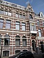
building in The Hague, Netherlands  | |||||
| Upload media | |||||
| Instance of | |||||
|---|---|---|---|---|---|
| Location | The Hague, South Holland, Netherlands | ||||
| Street address |
| ||||
| Architectural style | |||||
| Heritage designation |
| ||||
 | |||||
|
This is a category about rijksmonument number 18012
|
| Address |
|
Media in category "Sweelinckplein 12, The Hague"
The following 4 files are in this category, out of 4 total.
-
 Overzicht - 's-Gravenhage - 20090483 - RCE.jpg 1,200 × 962; 244 KB
-
 Overzicht - 's-Gravenhage - 20090484 - RCE.jpg 1,200 × 966; 237 KB
-

-
 RM18012 Den Haag - Sweelinckplein 13.jpg 2,448 × 3,264; 2.44 MB


