Category:Survey of Palestine maps of Jerusalem
Jump to navigation
Jump to search
Subcategories
This category has the following 3 subcategories, out of 3 total.
Media in category "Survey of Palestine maps of Jerusalem"
The following 11 files are in this category, out of 11 total.
-
 Environs of Jerusalem-NLI.jpg 10,091 × 7,744; 5.73 MB
-
 Guide map of Jerusalem - Drawn by Survey Directorate H.Q. Pal & T.J.jpg 1,039 × 1,455; 308 KB
-

-

-

-
 Jerusalem1925.jpg 18,525 × 12,383; 52.66 MB
-
 JerusalemWest1943.jpg 1,200 × 852; 290 KB
-
 MamillaDistrict1946.jpg 606 × 664; 227 KB
-
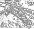 MeaShearim.png 1,083 × 907; 209 KB
-
 MountZion1946.jpg 890 × 605; 215 KB
-
 WadiAlJoz1946.png 1,179 × 1,126; 1.07 MB


