Category:Sundial at St Bartholomew's Church, Thurstaston
Jump to navigation
Jump to search
| Object location | | View all coordinates using: OpenStreetMap |
|---|
This is a category about listed building number 1115752. |
sundial in Thurstaston, Merseyside, England, UK  | |||||
| Upload media | |||||
| Instance of | |||||
|---|---|---|---|---|---|
| Made from material | |||||
| Location | Thurstaston, Wirral, Merseyside, North West England, England | ||||
| Heritage designation |
| ||||
| Inception |
| ||||
 | |||||
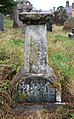
Grade II listed 1844 sundial, lacking plate and gnomon, in the churchyard of St Bartholomew, Thurstaston.
Media in category "Sundial at St Bartholomew's Church, Thurstaston"
The following 4 files are in this category, out of 4 total.
-
 Sundial at St Bartholomew's church, Thurstaston 1.jpg 4,300 × 3,209; 12.04 MB
-
 Sundial at St Bartholomew's church, Thurstaston 2.jpg 3,468 × 5,202; 14.61 MB
-
 Sundial at St Bartholomew's church, Thurstaston 3.jpg 3,174 × 5,100; 10.89 MB
-
 Sundial at St Bartholomew's church, Thurstaston 4.jpg 3,490 × 5,235; 17.79 MB


