Category:Summerland Oil Field
Jump to navigation
Jump to search
oil field near Santa Barbara, California | |||||
| Upload media | |||||
| Instance of | |||||
|---|---|---|---|---|---|
| Location |
| ||||
 | |||||
Media in category "Summerland Oil Field"
The following 15 files are in this category, out of 15 total.
-
 California mineral production for 1920, with county maps (1921) (14577784467).jpg 2,816 × 1,592; 561 KB
-

-

-
 HD.11.007 (10967618725).jpg 3,200 × 2,195; 761 KB
-
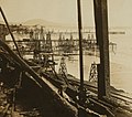
 Oil wells in the ocean, Summerland, Calif. LCCN2004677435.jpg 1,536 × 1,110; 272 KB
-
 Oil wells in the sea, Summerland, Coast Highway, California (16356193356).jpg 1,036 × 674; 214 KB
-
 Oil wells just offshore at Summerland, California, c.1915.jpg 1,512 × 872; 278 KB
-
 Summerland oil wells on the Pacific coast, ca.1901-1903 (CHS-2229).jpg 5,500 × 4,424; 2.32 MB
-
 Summerland oil wells on the Pacific coast, ca.1901-1903 (CHS-2230).jpg 5,500 × 4,404; 2.23 MB
-
 SummerlandDetail.jpg 3,300 × 2,550; 896 KB
-
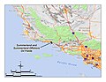 SummerlandLocation.jpg 3,300 × 2,550; 1 MB
-
 SummerlandOilField.jpg 700 × 504; 174 KB
-
 SummerlandOilFieldToday1.jpg 2,259 × 1,356; 1.28 MB
-
-

_(14577784467).jpg)

.jpg)

.jpg)

.jpg)
.jpg)


.jpg)

Categories:
- Oil fields in Santa Barbara County, California
- Summerland, California
- Oil fields in California
- Onshore oil fields in California
- Offshore oil fields of California
- Santa Barbara Channel
- Abandoned oil fields in California
- Casitas Formation
- Oil fields associated with the Vaqueros Formation
- Oil fields associated with the Rincon Formation (U.S. geology)