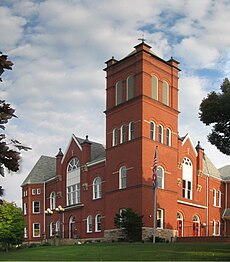
Category:Sullivan County, Pennsylvania
Jump to navigation
Jump to search
Counties of Pennsylvania : Adams · Allegheny · Armstrong · Beaver · Bedford · Berks · Blair · Bradford · Bucks · Butler · Cambria · Cameron · Carbon · Centre · Chester · Clarion · Clearfield · Clinton · Columbia · Crawford · Cumberland · Dauphin · Delaware · Elk · Erie · Fayette · Forest · Franklin · Fulton · Greene · Huntingdon · Indiana · Jefferson · Juniata · Lackawanna · Lancaster · Lawrence · Lebanon · Lehigh · Luzerne · Lycoming · McKean · Mercer · Mifflin · Monroe · Montgomery · Montour · Northampton · Northumberland · Perry · Philadelphia · Pike · Potter · Schuylkill · Snyder · Somerset · Sullivan · Susquehanna · Tioga · Union · Venango · Warren · Washington · Wayne · Westmoreland · Wyoming · York
county in Pennsylvania, United States | |||||
| Upload media | |||||
| Instance of | |||||
|---|---|---|---|---|---|
| Named after | |||||
| Location | Pennsylvania | ||||
| Capital | |||||
| Inception |
| ||||
| Population |
| ||||
| Area |
| ||||
| Different from | |||||
| official website | |||||
 | |||||
Subcategories
This category has the following 19 subcategories, out of 19 total.
Media in category "Sullivan County, Pennsylvania"
The following 38 files are in this category, out of 38 total.
-
Above Ticklish Rock.jpg 3,000 × 4,000; 3.22 MB
-
Big Run falls 2.JPG 3,088 × 2,056; 1.91 MB
-
Big Run looking downstream.JPG 2,056 × 3,088; 1.79 MB
-
Big Run looking upstream.JPG 2,056 × 3,088; 2.04 MB
-
East Branch Fishing Creek (Revisited) (9) (31751797562).jpg 2,651 × 1,463; 3.54 MB
-
East Branch Fishing Creek in June 2015 (2).JPG 3,088 × 1,927; 2.67 MB
-
East Branch Fishing Creek in June 2015.JPG 3,088 × 2,056; 2.1 MB
-
East Branch Fishing Creek satellite map.PNG 288 × 495; 270 KB
-
Fishing Creek in the Allegheny Front.jpg 4,943 × 3,584; 15.84 MB
-
Flickr - Nicholas T - Immersed.jpg 2,304 × 3,072; 5.08 MB
-
Flickr - Nicholas T - Lakeside (1).jpg 4,320 × 3,009; 10.43 MB
-
Flickr - Nicholas T - Lakeside (2).jpg 4,320 × 3,240; 7.66 MB
-
Flickr - Nicholas T - Ruinous.jpg 3,240 × 4,320; 10.84 MB
-
Flickr - Nicholas T - Sky Comb.jpg 3,648 × 2,736; 6.11 MB
-
Lead Run looking downstream.JPG 2,056 × 3,088; 1.92 MB
-
Lead Run looking upstream.JPG 3,088 × 1,948; 1.73 MB
-
Loyalsock Creek Cascades.jpg 4,320 × 3,240; 12.41 MB
-
Loyalsock State Forest High Knob Panorama 4.jpg 2,048 × 1,536; 878 KB
-
Loyalsock State Forest Lookout.jpg 3,418 × 3,021; 8.03 MB
-
Loyalsock State Forest.jpg 2,740 × 2,112; 3.78 MB
-
LSF Top-Down.jpg 3,240 × 4,320; 14.01 MB
-
Main Falls on Pigeon Run.jpg 667 × 962; 273 KB
-
Mildred, PA Keystone Marker crop.jpg 690 × 480; 257 KB
-
Mildred, PA Keystone Marker.jpg 768 × 1,024; 157 KB
-
Muncy Valley, PA Keystone Marker.jpg 1,024 × 768; 615 KB
-
North Mountain from Central.JPG 2,256 × 1,504; 2.42 MB
-
Oxhorn Run looking downstream.JPG 1,504 × 2,256; 3.03 MB
-
Oxhorn Run looking upstream.JPG 2,256 × 1,504; 3.4 MB
-
Painter Run looking downstream above Oxhorn Run.JPG 2,256 × 1,504; 3.66 MB
-
Painter Run looking upstream above Oxhorn Run 1.JPG 1,504 × 2,256; 3.29 MB
-
Rapids on Painter Run.JPG 2,256 × 1,504; 2.83 MB
-
Ticklish Rock Trailhead.jpg 4,000 × 3,000; 4.52 MB
-
Ticklish Rock.jpg 3,000 × 4,000; 3.92 MB
-
USA Sullivan County, Pennsylvania age pyramid.svg 520 × 600; 8 KB
-
Waterfall just below the path.jpg 1,000 × 667; 282 KB
-
Waterfall on Big Run.jpg 667 × 968; 281 KB
-
Wreaths at Ticklish Rock.jpg 3,000 × 4,000; 5.34 MB
-
Wyalusing Path Historical Marker.JPG 2,048 × 1,536; 1.14 MB


