Category:Strood
Jump to navigation
Jump to search
town in the unitary authority of Medway in South East England  | |||||
| Upload media | |||||
| Instance of | |||||
|---|---|---|---|---|---|
| Location | Medway, Kent, South East England, England | ||||
| Elevation above sea level |
| ||||
| Different from | |||||
 | |||||
Subcategories
This category has the following 15 subcategories, out of 15 total.
A
B
H
- History of Strood (1899) (3 F)
M
- Medway Viaducts (39 F)
R
- Railway bridges in Strood (33 F)
- Rede Common local nature reserve (40 F)
S
- Salter's Cross (5 F)
- Streets in Strood (6 F)
- Strood Community Trail (4 F)
- Strood railway station (98 F)
Media in category "Strood"
The following 200 files are in this category, out of 896 total.
(previous page) (next page)-
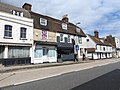
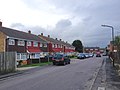
 14 -18 London Road, Strood 4722.jpg 4,608 × 3,456; 3.12 MB
-
 18 to 6 London Road, Strood 4723.jpg 4,608 × 3,456; 3.49 MB
-
 1863 Strood.jpg 702 × 749; 113 KB
-
 2, 4 London Road, Strood 4725.jpg 4,608 × 3,456; 3.38 MB
-
 2, 4 London Road, Strood 4726.jpg 4,608 × 3,456; 3.22 MB
-
 2, 4, 6, 8 London Road, Strood 4724.jpg 4,608 × 3,456; 3.07 MB
-
 2016 Strood Christmas 2020.jpg 4,608 × 3,456; 3.6 MB
-
 2016 Strood Christmas 2021.jpg 4,608 × 3,456; 3.44 MB
-
 4, London Road, Strood - geograph.org.uk - 5295619.jpg 2,448 × 3,264; 2.24 MB
-

-

-
 5Northcote Road recreation ground football goal posts 5087.jpg 4,608 × 3,456; 3.4 MB
-
 6, 8 London Road, Strood 4727.jpg 4,608 × 3,456; 3.2 MB
-
 68, Cuxton Road - geograph.org.uk - 5883075.jpg 2,448 × 3,264; 2.3 MB
-
 A2 London Road, Strood - geograph.org.uk - 1912104.jpg 2,048 × 1,536; 1.23 MB
-
 A2 Road Footpath leading to Northcote Road recreation ground 4964.jpg 4,608 × 3,456; 3.3 MB
-
 A2 road in Strood in February 9907.jpg 3,072 × 4,096; 2.83 MB
-
 A2 road in Strood in February 9908.jpg 3,072 × 4,096; 3.33 MB
-
 A2 road Salter's Cross Co-op 4851.jpg 4,608 × 3,456; 3.35 MB
-
 A2 road Salter's Cross Co-op4852.jpg 4,608 × 3,456; 3.43 MB
-
 A2 road, around Three Crutches, Strood 4880.jpg 4,608 × 3,456; 3.31 MB
-
 A2 road, around Three Crutches, Strood 4881.jpg 4,608 × 3,456; 3.45 MB
-
 A2 road, around Three Crutches, Strood 4883.jpg 4,608 × 3,456; 3.2 MB
-
 A2 road, around Three Crutches, Strood 4884.jpg 4,608 × 3,456; 3.4 MB
-
 A2 road, around Three Crutches, Strood 4885.jpg 4,608 × 3,456; 3.45 MB
-
 A2 road, around Three Crutches, Strood 4886.jpg 4,608 × 3,456; 3.39 MB
-
 A2 road, around Three Crutches, Strood 4887.jpg 4,608 × 3,456; 3.27 MB
-
 A2 road, around Three Crutches, Strood 4888.jpg 4,608 × 3,456; 3.28 MB
-
 A2 road, around Three Crutches, Strood 4889.jpg 4,608 × 3,456; 3.38 MB
-
 A2 road, around Three Crutches, Strood 4890.jpg 4,608 × 3,456; 3.47 MB
-
 A2 road, around Three Crutches, Strood 4891.jpg 4,608 × 3,456; 3.4 MB
-
 A2 road, around Three Crutches, Strood reseeding verge 4882.jpg 4,608 × 3,456; 3.55 MB
-
 A2 road, bordering Rede Common, Strood 4946.jpg 4,608 × 3,456; 3.32 MB
-
 A2 road, bordering Rede Common, Strood 4949.jpg 4,608 × 3,456; 3.51 MB
-
 A2 road, bordering Rede Common, Strood 4950.jpg 4,608 × 3,456; 3.47 MB
-
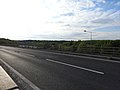
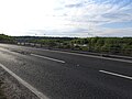
 A2 road, M2 junction, Strood 4915.jpg 4,608 × 3,456; 3.29 MB
-
 A2 road, M2 junction, Strood 4916.jpg 4,608 × 3,456; 3.41 MB
-
 A2 road, M2 junction, Strood 4917.jpg 4,608 × 3,456; 3.17 MB
-
 A2 road, M2 junction, Strood 4918.jpg 4,608 × 3,456; 3.17 MB
-
 A2 road, M2 junction, Strood 4919.jpg 4,608 × 3,456; 3.26 MB
-
 A2 road, M2 junction, Strood 4920.jpg 4,608 × 3,456; 3.24 MB
-
 A2 road, M2 junction, Strood 4921.jpg 4,608 × 3,456; 3.11 MB
-
 A2 road, M2 junction, Strood 4922.jpg 4,608 × 3,456; 3.4 MB
-
 A2 road, Strood 4941.jpg 4,608 × 3,456; 3.21 MB
-
 A2 road, Strood 4942.jpg 4,608 × 3,456; 3.32 MB
-
 A2 road, Strood 4943.jpg 4,608 × 3,456; 3.44 MB
-
 A2 road, Strood 4944.jpg 4,608 × 3,456; 3.38 MB
-
 A2 road, Strood 4945.jpg 4,608 × 3,456; 3.29 MB
-
 A2 road, Strood 4948.jpg 4,608 × 3,456; 3.01 MB
-
 A2 road, Strood 4951.jpg 4,608 × 3,456; 3.47 MB
-
 A2 road, Strood 4962.jpg 4,608 × 3,456; 3.31 MB
-
 A2 road, Strood 4963.jpg 4,608 × 3,456; 3.34 MB
-
 A2 road,Salters Cross,Strood 4892.jpg 4,608 × 3,456; 3.26 MB
-
 A2 Watling Street, Strood - geograph.org.uk - 1912096.jpg 2,048 × 1,536; 1.06 MB
-
 Abbey Road, Strood - geograph.org.uk - 3677243.jpg 3,488 × 2,616; 2.26 MB
-
 Albatross Avenue, Strood - geograph.org.uk - 4233758.jpg 3,264 × 2,448; 1.83 MB
-
 Albatross Avenue, Strood - geograph.org.uk - 4233806.jpg 3,264 × 2,448; 1.76 MB
-
 All faiths Primary, Strood 4729.jpg 4,608 × 3,456; 3.39 MB
-
 All faiths Primary, Strood 4755.jpg 4,608 × 3,456; 3.16 MB
-
 All faiths Primary, Strood 4756.jpg 4,608 × 3,456; 3.26 MB
-
 Alleyway from Darnley Road to Willow , Strood 5016.jpg 4,608 × 3,456; 3.51 MB
-
 Alleyway from Darnley Road to Willow , Strood 5017.jpg 4,608 × 3,456; 3.59 MB
-
 Alleyway from Darnley Road to Willow , Strood 5018.jpg 4,608 × 3,456; 3.42 MB
-
 Alleyway from Darnley Road to Willow , Strood 5019.jpg 4,608 × 3,456; 3.41 MB
-
 Alleyway from Darnley Road to Willow , Strood 5020.jpg 4,608 × 3,456; 3.47 MB
-
 Alleyway from Darnley Road to Willow , Strood 5021.jpg 4,608 × 3,456; 3.11 MB
-
 Allington Drive, Strood - geograph.org.uk - 4226721.jpg 3,264 × 2,448; 1.74 MB
-
 Alma Place, Strood - geograph.org.uk - 4116991.jpg 3,264 × 2,448; 2.9 MB
-
 Alma Place, Strood - geograph.org.uk - 5130176.jpg 3,264 × 2,448; 1.7 MB
-
 Apartment blocks on Albatross Avenue - geograph.org.uk - 2871212.jpg 640 × 480; 95 KB
-
 Apartment blocks on Albatross Avenue - geograph.org.uk - 2871214.jpg 640 × 480; 78 KB
-
 Arran Green, Strood - geograph.org.uk - 4233740.jpg 3,264 × 2,448; 1.85 MB
-
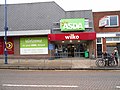 Asda and Wilko, High Street, Strood.jpg 5,152 × 3,864; 4.51 MB
-
 Aveling and Porter, Strood - geograph.org.uk - 1729066.jpg 3,488 × 2,616; 2.24 MB
-
 Aveling and Porter, Strood - geograph.org.uk - 1729074.jpg 3,488 × 2,616; 2.35 MB
-
 Aveling Court, North Street, Strood - geograph.org.uk - 725074.jpg 640 × 480; 70 KB
-
 Aveling&Porter Strood RoadRoller.jpg 1,280 × 960; 483 KB
-

-
 Ballard Business Park, Strood - geograph.org.uk - 1359948.jpg 640 × 480; 59 KB
-
 Bangor Road, Strood - geograph.org.uk - 4233839.jpg 3,264 × 2,448; 1.51 MB
-
 Barn cottage, Three Crutches, Strood 4896.jpg 4,608 × 3,456; 3.09 MB
-
 Barton Road bakery, Strood 4728.jpg 4,608 × 3,456; 3.21 MB
-
 Barton Road, Strood - geograph.org.uk - 3819463.jpg 3,488 × 2,616; 2.04 MB
-
 Beaufort Road, Strood - geograph.org.uk - 4226698.jpg 3,264 × 2,448; 1.72 MB
-
 Beech Road, Strood - geograph.org.uk - 4913259.jpg 3,264 × 2,448; 1.43 MB
-
 Bligh Junior School staff parking, Strood 4879.jpg 4,608 × 3,456; 3.4 MB
-
 Bligh Junior School, Strood 4870.jpg 4,608 × 3,456; 3.36 MB
-
 Bligh Junior School, Strood 4873.jpg 4,608 × 3,456; 3.19 MB
-
 Bligh Junior School, Strood 4874.jpg 4,608 × 3,456; 3.4 MB
-
 Bligh Junior School, Strood 4878.jpg 4,608 × 3,456; 3.34 MB
-
 Bligh Rec, Strood 4876.jpg 4,608 × 3,456; 3.25 MB
-
 Bligh sports field, Strood 4877.jpg 4,608 × 3,456; 3.33 MB
-
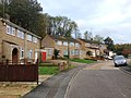
 Bligh Way estate, Strood - geograph.org.uk - 323109.jpg 640 × 480; 28 KB
-
 Bligh Way, Strood - geograph.org.uk - 1355756.jpg 640 × 480; 45 KB
-
 Bligh Way, Strood - geograph.org.uk - 4233711.jpg 3,264 × 2,448; 1.61 MB
-
 Bligh Way, Strood - geograph.org.uk - 4233725.jpg 3,264 × 2,448; 1.61 MB
-
 Bligh, Strood 4867.jpg 4,608 × 3,456; 3.31 MB
-
 Bligh, Strood 4868.jpg 4,608 × 3,456; 3.26 MB
-
 Bligh, Strood 4869.jpg 4,608 × 3,456; 3.27 MB
-
 Bligh, Strood 4871.jpg 4,608 × 3,456; 3.29 MB
-
 Bligh, Strood 4872.jpg 4,608 × 3,456; 3.45 MB
-
 Boarded Up Shop, Cuxton Road, Strood - geograph.org.uk - 715599.jpg 640 × 480; 74 KB
-
 Boats on the Medway, Strood - geograph.org.uk - 1346246.jpg 640 × 480; 84 KB
-
 Boats' graveyard at Strood - geograph.org.uk - 3602360.jpg 4,000 × 3,000; 4.4 MB
-
 Bootham Close, Strood - geograph.org.uk - 4233871.jpg 3,264 × 2,448; 2.11 MB
-
 Bowesden Lane, near Shorne - geograph.org.uk - 1399182.jpg 640 × 480; 134 KB
-
 Brasted Court, Strood - geograph.org.uk - 4847597.jpg 3,264 × 2,448; 1.88 MB
-
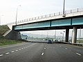 Bridge over M2, at junction 1 - geograph.org.uk - 1253043.jpg 640 × 480; 64 KB
-
 Bridge Reach, River Medway - geograph.org.uk - 1341638.jpg 640 × 480; 66 KB
-
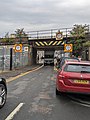 Bridge strike Bryant Road Bridge, 900.jpg 3,024 × 4,032; 2.81 MB
-
 Bridge strike Bryant Road Bridge, 901.jpg 3,024 × 4,032; 12.23 MB
-
 Bridge strike Bryant Road Bridge, 902.jpg 3,024 × 4,032; 7.96 MB
-
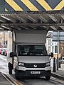 Bridge strike Bryant Road Bridge, 903.jpg 3,024 × 4,032; 8.21 MB
-
 Bridge strike Bryant Road Bridge, 904.jpg 3,024 × 4,032; 1.64 MB
-
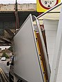 Bridge strike Bryant Road Bridge, 905.jpg 3,024 × 4,032; 1.93 MB
-
 Bridge strike Bryant Road Bridge, 906.jpg 3,024 × 4,032; 3.27 MB
-
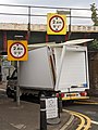 Bridge strike Bryant Road Bridge, 907.jpg 3,024 × 4,032; 2.07 MB
-
 Bridge strike Bryant Road Bridge, 908.jpg 3,024 × 4,032; 2.65 MB
-
 Bridge strike Bryant Road Bridge, 909.jpg 1,033 × 1,545; 311 KB
-
 Bridge strike Bryant Road Bridge, 910.jpg 3,024 × 4,032; 10.91 MB
-
 Bridge strike Bryant Road Bridge, 911.jpg 3,024 × 4,032; 15.3 MB
-
 Bristol Close, Strood - geograph.org.uk - 4233848.jpg 3,264 × 2,448; 1.78 MB
-
 Brompton Farm Road, Strood - geograph.org.uk - 4847549.jpg 3,264 × 2,448; 1.81 MB
-
 Brompton Lane, Strood - geograph.org.uk - 3780600.jpg 3,488 × 2,616; 1.91 MB
-
 Broom Hill Road, Strood - geograph.org.uk - 2044713.jpg 2,842 × 2,028; 1.5 MB
-
 Broom Hill Sundial 8822 (03).jpg 3,456 × 4,608; 5.82 MB
-
 Broom Hill Sundial 8830.jpg 4,608 × 3,456; 5.9 MB
-
 Broomhill old orchard, Strood 5145.jpg 4,608 × 3,456; 3.6 MB
-
 Broomhill old orchard, Strood 5146.jpg 4,608 × 3,456; 3.46 MB
-
 Broomhill Park, Strood - geograph.org.uk - 880957.jpg 640 × 480; 81 KB
-
 Broomhill Park, Strood entrance 5141.jpg 4,608 × 3,456; 3.54 MB
-
 Broomhill Park, Strood entrance 5142.jpg 4,608 × 3,456; 3.51 MB
-
 Broomhill Park, Strood entrance 5143.jpg 4,608 × 3,456; 3.52 MB
-
 Broomhill Park, Strood entrance 5144.jpg 4,608 × 3,456; 3.59 MB
-
 Broomhill Road, Strood - geograph.org.uk - 4847578.jpg 3,264 × 2,448; 1.85 MB
-
 Broomhill, Strood 5138.jpg 4,608 × 3,456; 3.46 MB
-
 Broomhill, Strood 5147.jpg 4,608 × 3,456; 3.55 MB
-
 Broomhill, Strood 5148.jpg 4,608 × 3,456; 3.47 MB
-
 Broomhill, Strood 5149.jpg 4,608 × 3,456; 3.61 MB
-
 Broomhill, Strood 5151.jpg 4,608 × 3,456; 3.57 MB
-
 Broomhill, Strood 5152.jpg 4,608 × 3,456; 3.48 MB
-
 Broomhill, Strood 5153.jpg 4,608 × 3,456; 3.48 MB
-
 Broomhill, Strood 5154.jpg 4,608 × 3,456; 3.5 MB
-
 Broomhill, Strood sundial 5150.jpg 4,608 × 3,456; 3.34 MB
-
 Broomhill, Strood Vista 5135.jpg 4,608 × 3,456; 3.4 MB
-
 Broomhill, Strood Vista 5137.jpg 4,608 × 3,456; 3.39 MB
-
 Broomhill, StroodVista 5136.jpg 4,608 × 3,456; 3.3 MB
-
 Bryant House, Strood - geograph.org.uk - 3819481.jpg 3,488 × 2,616; 2.61 MB
-
 Bryant Road bridge, Strood in February 9904.jpg 3,072 × 4,096; 2.45 MB
-
 Bryant Road bridge, Strood in February 9905.jpg 3,072 × 4,096; 2.78 MB
-
 Bryant Road, Strood - geograph.org.uk - 3819476.jpg 3,488 × 2,616; 2.21 MB
-
 Bryant Road, Strood in February 9901.jpg 3,072 × 4,096; 1.35 MB
-
 Bryant Road, Strood in February 9903.jpg 3,072 × 4,096; 2.74 MB
-
 Bryant Road, Strood vista 1794.jpg 4,608 × 3,456; 3.41 MB
-
 Bryant Road, Strood vista.jpg 4,608 × 3,456; 3.34 MB
-
 Burleigh Close, Strood - geograph.org.uk - 4226758.jpg 3,264 × 2,448; 2.03 MB
-
 Butlers Park Way, Strood - geograph.org.uk - 4712230.jpg 3,264 × 2,448; 1.29 MB
-
 Canal Road, Strood - geograph.org.uk - 1171441.jpg 640 × 480; 58 KB
-
 Canal Road, Strood - geograph.org.uk - 1729108.jpg 3,488 × 2,616; 2.23 MB
-
 Canal Road, Strood - geograph.org.uk - 710472.jpg 640 × 480; 58 KB
-
 Canal Road, Strood - geograph.org.uk - 880949.jpg 640 × 480; 73 KB
-
 Carisbrooke Road, Strood - geograph.org.uk - 4226678.jpg 3,264 × 2,448; 1.85 MB
-
 Carnation Road, Strood - geograph.org.uk - 4226796.jpg 3,264 × 2,448; 1.64 MB
-
 Carnation Road, Strood - geograph.org.uk - 4233666.jpg 3,121 × 2,446; 1.62 MB
-
 Castle View Road, Strood - geograph.org.uk - 4226636.jpg 3,264 × 2,448; 1.86 MB
-
 Castleview Road, Strood 4772.jpg 4,608 × 3,456; 3.42 MB
-
 Castleview Road, Strood 4775.jpg 4,608 × 3,456; 3.46 MB
-
 Castleview Road, Strood 4776.jpg 4,608 × 3,456; 3.35 MB
-
 Castleview Road, Strood 4961.jpg 4,608 × 3,456; 3.38 MB
-
 Cedar Academy Strood 5025.jpg 4,608 × 3,456; 3.21 MB
-
 Cedar Academy Strood 5026.jpg 4,608 × 3,456; 3.46 MB
-
 Cedar Academy Strood 5028.jpg 4,608 × 3,456; 3.53 MB
-
 Cedar Road, Strood - geograph.org.uk - 1259352.jpg 640 × 480; 67 KB
-
 Cedar Road, Strood - geograph.org.uk - 3819339.jpg 3,488 × 2,616; 2.03 MB
-
 Cedar Road, Strood - geograph.org.uk - 4913262.jpg 3,264 × 2,448; 1.61 MB
-
 Cedar Road, Strood - geograph.org.uk - 4913264.jpg 3,027 × 2,271; 1.16 MB
-
 Cedar Road, Strood 5024.jpg 4,608 × 3,456; 3.12 MB
-

-

-
 Chapter Road, Strood - geograph.org.uk - 4226658.jpg 3,264 × 2,448; 1.92 MB
-
 Chelmsford Road, Strood - geograph.org.uk - 4233707.jpg 3,264 × 2,448; 2.66 MB
-
 Chelmsford Road, Strood - geograph.org.uk - 4233844.jpg 3,264 × 2,448; 1.63 MB
-
 Chequers Court, Strood - geograph.org.uk - 4847594.jpg 3,264 × 2,448; 2.16 MB
-
 Chestnut Road, Strood - geograph.org.uk - 4913286.jpg 3,264 × 2,448; 1.84 MB
-
 Chetney Close, Strood - geograph.org.uk - 4226809.jpg 3,264 × 2,448; 1.68 MB
-
 Christmas tree, Strood - geograph.org.uk - 1628292.jpg 640 × 480; 99 KB
-
 Church Green, Strood - geograph.org.uk - 1083906.jpg 640 × 480; 72 KB
-
 Cineworld seen from the North Downs Way - geograph.org.uk - 6032811.jpg 4,000 × 3,000; 4.96 MB
-
 Civic Centre, Strood - geograph.org.uk - 1043615.jpg 481 × 640; 66 KB
-
 Clarendon Drive, Strood - geograph.org.uk - 4847587.jpg 3,264 × 2,448; 2.38 MB
-
 Cliffe Road, Strood (1) - geograph.org.uk - 880954.jpg 640 × 480; 83 KB
-
 Cliffe Road, Strood (2) - geograph.org.uk - 880955.jpg 640 × 480; 73 KB
-
 Clinton Avenue, Strood - geograph.org.uk - 4226777.jpg 3,262 × 1,915; 1.13 MB
-
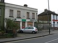
 Closed Pub in Strood - geograph.org.uk - 1053627.jpg 640 × 481; 61 KB
-
 Closed road to Temple Marsh - geograph.org.uk - 3828628.jpg 4,288 × 3,216; 4.91 MB
-
 Coach and Horses public house, Strood - geograph.org.uk - 1911522.jpg 2,048 × 1,536; 1.25 MB
-
 Cobham Close, Strood - geograph.org.uk - 4233643.jpg 3,264 × 2,448; 2.59 MB
-
 Collis Street, Strood - geograph.org.uk - 3780584.jpg 3,488 × 2,616; 1.96 MB
-
 Columbine Avenue 4806.jpg 4,608 × 3,456; 3.12 MB
-
 Columbine Close, Strood - geograph.org.uk - 2099415.jpg 3,488 × 2,616; 2.02 MB


.jpg)
.jpg)


.jpg)


_-_geograph.org.uk_-_880954.jpg)
_-_geograph.org.uk_-_880955.jpg)


