Category:Streetcars on Bloor Street, Toronto
Jump to navigation
Jump to search
Former Toronto streetcar line (closed 1966) | |||||
| Upload media | |||||
| Instance of |
| ||||
|---|---|---|---|---|---|
| Location |
| ||||
| |||||
Early in the 20th Century Toronto had an even more extensive network of streetcars than it does today. The two most frequently used routes, on Yonge Street and the Bloor Street--Danforth Avenue route.
Media in category "Streetcars on Bloor Street, Toronto"
The following 7 files are in this category, out of 7 total.
-
 Aerial view of Dundas West and Bloor in 1927.jpg 590 × 487; 80 KB
-
 Bloor Street, looking west at St Thomas Street.jpg 1,034 × 684; 83 KB
-
-
 Peter Witt streetcar on Bloor Street, west of Spadina Avenue.jpg 1,050 × 734; 205 KB
-
 Postcard of a streetcar at the corner of Dovercourt and Bloor.jpg 1,000 × 630; 102 KB
-
 Postcard showing a streetcar crossing the Prince Edward Viaduct.jpg 1,100 × 729; 98 KB
-
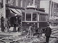
 Track work at Dundas West and Bloor in 1925.jpg 590 × 417; 86 KB


