Category:Stow Bedon
Jump to navigation
Jump to search
English: Stow Bedon is a village of 287 inhabitants in the Breckland district of the English county of Norfolk.
village in the United Kingdom  | |||||
| Upload media | |||||
| Instance of | |||||
|---|---|---|---|---|---|
| Location | Stow Bedon and Breckles, Breckland, Norfolk, East of England, England | ||||
 | |||||
Media in category "Stow Bedon"
The following 133 files are in this category, out of 133 total.
-
 A Norfolk Lane - geograph.org.uk - 3551073.jpg 1,024 × 768; 259 KB
-
 A1075 near Lodge Farm - geograph.org.uk - 4351662.jpg 640 × 480; 100 KB
-
 A1075 to Thetford - geograph.org.uk - 6177290.jpg 1,024 × 576; 216 KB
-
 A1075 to Watton - geograph.org.uk - 6177277.jpg 1,024 × 576; 240 KB
-
 Access road to Watering Farm - geograph.org.uk - 5918742.jpg 4,608 × 3,456; 5.67 MB
-
 Almost time to Give Way approaching Bray's Lane - geograph.org.uk - 5965334.jpg 3,456 × 2,592; 3.94 MB
-
 Approaching Road Junction - geograph.org.uk - 5192459.jpg 1,024 × 768; 211 KB
-
 B1111 in Breckles - geograph.org.uk - 6185438.jpg 1,024 × 768; 257 KB
-
 Barn at Flybarn Farm Rockland - geograph.org.uk - 5965329.jpg 3,456 × 2,592; 3.83 MB
-
 Barrier to vehicle access - geograph.org.uk - 6018354.jpg 4,608 × 3,456; 2.37 MB
-

-
 Biffa award sign - geograph.org.uk - 6162658.jpg 1,024 × 769; 261 KB
-

-
 Bray's Lane from near Flybarn Farm - geograph.org.uk - 5965326.jpg 3,456 × 2,592; 3.82 MB
-
 Breckles War Memorial - geograph.org.uk - 5025694.jpg 2,592 × 3,456; 2.85 MB
-
 Breckles, St. Margaret's Church - geograph.org.uk - 5101892.jpg 3,678 × 2,456; 6.09 MB
-

-
 Breckles, St. Margaret's Church, The chancel from the south - geograph.org.uk - 5101921.jpg 3,678 × 2,456; 5.32 MB
-
-
 Breckles, St. Margaret's Church, The nave - geograph.org.uk - 5101897.jpg 5,335 × 3,412; 7.37 MB
-
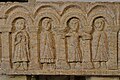
 Breckles, St. Margaret's Church, The Norman font 1 - geograph.org.uk - 5101898.jpg 3,611 × 2,345; 3.7 MB
-

-

-
-

-

-

-

-
 Breckles, St. Margaret's Church, The Norman font 8 - geograph.org.uk - 5101918.jpg 3,679 × 2,456; 4.02 MB
-
 Breckles, St. Margaret's Church, The Norman font 9 - geograph.org.uk - 5101920.jpg 4,553 × 2,955; 5.67 MB
-

-

-

-

-

-
 Car Park on Watton Road, Stow Bedon - geograph.org.uk - 5716307.jpg 2,048 × 1,536; 1.77 MB
-
 Cleared trees near Peels Farm - geograph.org.uk - 4943589.jpg 1,600 × 1,200; 922 KB
-
 Ditch beside Winter cereal crop - geograph.org.uk - 6058601.jpg 1,024 × 768; 307 KB
-
 Ditch beside Winter cereal crop - geograph.org.uk - 6058602.jpg 1,024 × 672; 227 KB
-
 East along minor country road - geograph.org.uk - 6185422.jpg 1,024 × 749; 301 KB
-
 Easterly view into Stowbedon Common - geograph.org.uk - 6162701.jpg 1,024 × 768; 497 KB
-
 Edge of Stowbedon Common and cereal crop - geograph.org.uk - 6162641.jpg 1,024 × 769; 325 KB
-
 Entering Lower Stow Bedon - geograph.org.uk - 4943598.jpg 1,600 × 1,200; 848 KB
-
 Entrance to Old Hall Farm - geograph.org.uk - 6185445.jpg 1,024 × 768; 278 KB
-
 Entrance to Pingo Trail car park - geograph.org.uk - 6162591.jpg 1,024 × 768; 346 KB
-
 Farm track beside hedge - geograph.org.uk - 6185453.jpg 1,024 × 768; 197 KB
-
 Field at Stow Bedon and empty clouds - geograph.org.uk - 5965313.jpg 3,456 × 2,592; 4.6 MB
-
 Field by the B1111, Breckles - geograph.org.uk - 5717437.jpg 1,766 × 1,212; 1.46 MB
-
 Field in Lower Stow Bedon - geograph.org.uk - 4943562.jpg 1,600 × 1,200; 907 KB
-
 Field near Hillside - geograph.org.uk - 4943557.jpg 1,600 × 1,200; 792 KB
-
 Field near Lower Stow Bedon - geograph.org.uk - 4943571.jpg 1,600 × 1,200; 950 KB
-
 Flybarn Farm - geograph.org.uk - 4943546.jpg 1,600 × 1,200; 823 KB
-
 Flybarn Farm - geograph.org.uk - 4943549.jpg 1,600 × 1,200; 756 KB
-
 Forestry track at edge of plantation - geograph.org.uk - 5924300.jpg 4,608 × 3,456; 5.62 MB
-
 Gated Track - geograph.org.uk - 5192446.jpg 1,024 × 768; 236 KB
-
 Gravelpit Hill - geograph.org.uk - 3551080.jpg 1,024 × 768; 172 KB
-
 Great Eastern Pingo Trail sign - geograph.org.uk - 6161773.jpg 1,024 × 768; 375 KB
-
 Heading into the forest - geograph.org.uk - 6018366.jpg 4,608 × 3,456; 2.33 MB
-
 Heading south near Lodge Farm - geograph.org.uk - 4351660.jpg 640 × 480; 98 KB
-
 Heading towards A1075 - geograph.org.uk - 6185462.jpg 1,024 × 768; 227 KB
-
 Houses on Mere Road, Stow Bedon - geograph.org.uk - 5715779.jpg 2,209 × 1,632; 1.54 MB
-
 Junction of B1111 and A1075 - geograph.org.uk - 6177285.jpg 1,024 × 576; 154 KB
-
 Junction with Bray's Lane - geograph.org.uk - 4943499.jpg 1,600 × 1,200; 1.07 MB
-
 Leaving Lower Stow Bedon - geograph.org.uk - 4943551.jpg 1,600 × 1,200; 714 KB
-
 Locked entrance gate to Thompson Common - geograph.org.uk - 6162650.jpg 1,024 × 768; 447 KB
-
 Lodge Farm, Stow Bedon - geograph.org.uk - 4351657.jpg 640 × 480; 142 KB
-
 Looking along Low Road - geograph.org.uk - 6185427.jpg 1,024 × 768; 315 KB
-
 Looking North on Pingo trail - geograph.org.uk - 6052528.jpg 1,024 × 768; 383 KB
-
 Looking North on Pingo Trail - geograph.org.uk - 6162692.jpg 1,024 × 768; 458 KB
-
 Looking South down Pingo Trail - geograph.org.uk - 6162705.jpg 1,024 × 768; 444 KB
-
 Looking South on B1111 - geograph.org.uk - 6185442.jpg 1,024 × 768; 248 KB
-
 Low Road, Breckles - geograph.org.uk - 5716661.jpg 2,048 × 1,536; 1.77 MB
-
 Lower Stow Bedon - geograph.org.uk - 4943567.jpg 1,600 × 1,200; 939 KB
-
 Lower Stow Bedon from Gravelpit Hill - geograph.org.uk - 5965315.jpg 3,456 × 2,592; 3.89 MB
-
 Maize crop with environmental headland - geograph.org.uk - 6185430.jpg 1,024 × 768; 233 KB
-
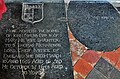
 Memorial to the crew of Blenheim V5851 crashed 7 July 1942 - geograph.org.uk - 6402279.jpg 4,608 × 3,072; 5.52 MB
-
 Memorial to the crew of Blenheim V5851 crashed 7 July 1942 - geograph.org.uk - 6402282.jpg 4,608 × 3,072; 5.72 MB
-
 Memorial to the crew of Blenheim V5851 crashed 7 July 1942 - geograph.org.uk - 6402288.jpg 4,608 × 3,072; 3.36 MB
-
 Minor road junction with A1075 - geograph.org.uk - 6185420.jpg 1,024 × 768; 312 KB
-
 New house at Hillside - geograph.org.uk - 4943554.jpg 1,600 × 1,200; 931 KB
-
 New house near Peels Farm - geograph.org.uk - 4943581.jpg 1,600 × 1,200; 680 KB
-
 Northerly on B1111 - geograph.org.uk - 6185451.jpg 1,024 × 768; 317 KB
-
 Ordnance Survey Flush Bracket G1551 - geograph.org.uk - 4290409.jpg 4,000 × 3,000; 3.79 MB
-
 OS Flush Bracket G1551 Stow Bedon - geograph.org.uk - 1888734.jpg 1,024 × 819; 387 KB
-
 Overgrown Pingo - geograph.org.uk - 6162613.jpg 1,024 × 768; 470 KB
-
 Peels Farm farmhouse from the road - geograph.org.uk - 5965321.jpg 3,456 × 2,592; 3.59 MB
-
 Pig tents - geograph.org.uk - 4943585.jpg 1,600 × 1,200; 601 KB
-
 Pingo trail from car park - geograph.org.uk - 6162597.jpg 1,024 × 768; 427 KB
-
 Pingo Trail map and information - geograph.org.uk - 6162685.jpg 1,024 × 768; 250 KB
-
 Pipe used for culvert - geograph.org.uk - 6071095.jpg 1,024 × 769; 316 KB
-
 Plastic covered field - geograph.org.uk - 4943493.jpg 1,600 × 1,400; 756 KB
-
 Primitive Methodist Church, Stow Bedon - geograph.org.uk - 569493.jpg 640 × 480; 176 KB
-
 Rest-a-while - geograph.org.uk - 399661.jpg 640 × 480; 135 KB
-
 Road from Lower Stow Bedon - geograph.org.uk - 4943580.jpg 1,600 × 1,200; 713 KB
-
 Road through Lower Stow Bedon - geograph.org.uk - 4943575.jpg 1,600 × 1,200; 692 KB
-
 Road to Lower Stow Bedon - geograph.org.uk - 4943595.jpg 1,600 × 1,200; 1.06 MB
-
 Scene around the village sign - geograph.org.uk - 6057706.jpg 3,264 × 2,448; 1.84 MB
-
 Scrub Woodland i Thompson Common - geograph.org.uk - 6162620.jpg 1,024 × 768; 400 KB
-
 South along the Peddars Way - geograph.org.uk - 5419662.jpg 800 × 626; 172 KB
-
 South Westerly view along forest edge - geograph.org.uk - 6071080.jpg 769 × 1,024; 419 KB
-
 Southeast on B1111 - geograph.org.uk - 6185458.jpg 1,024 × 768; 221 KB
-
 Southeast on B1111 - geograph.org.uk - 6185465.jpg 1,024 × 768; 230 KB
-

-
 Stow Bedon Village Sign - geograph.org.uk - 2086443.jpg 1,600 × 1,200; 652 KB
-
 Stow Bedon village sign - geograph.org.uk - 5715778.jpg 2,304 × 1,728; 2.38 MB
-
 Stow Bedon village sign - geograph.org.uk - 6057704.jpg 3,264 × 2,448; 1.82 MB
-
 Stow Bedon War Memorial - geograph.org.uk - 5558509.jpg 2,592 × 3,456; 3.2 MB
-
 Stow Bedon War Memorial - geograph.org.uk - 5558512.jpg 3,456 × 2,592; 3.91 MB
-
 Stow Bedon, Cherry Tree Farm, Huge field of sugar beet - geograph.org.uk - 5067957.jpg 3,678 × 2,456; 4.77 MB
-
 Stream near Lower Stow Bedon - geograph.org.uk - 4943596.jpg 1,600 × 1,200; 1.35 MB
-
 The B1111 at the junction of Watton Road - geograph.org.uk - 6407359.jpg 1,920 × 1,280; 1.19 MB
-
 The Church of St Margaret at Stow Bedon - geograph.org.uk - 4249943.jpg 4,000 × 3,000; 2.75 MB
-
 The Close, off the A1075 at Stow Bedon - geograph.org.uk - 4351654.jpg 640 × 480; 160 KB
-
 Track to open fields in forested area - geograph.org.uk - 5924308.jpg 4,608 × 3,456; 4.06 MB
-
 Trees by Low Road, Breckles - geograph.org.uk - 5716670.jpg 1,976 × 1,436; 1.88 MB
-
 Turkey unit - geograph.org.uk - 6029260.jpg 1,024 × 729; 177 KB
-
 View along public footpath, very little used - geograph.org.uk - 6109732.jpg 1,024 × 768; 430 KB
-
 View along trail - geograph.org.uk - 6052523.jpg 1,024 × 768; 400 KB
-

-

-
 View from forest edge - geograph.org.uk - 6071101.jpg 1,024 × 769; 294 KB
-
 View from Pingo Trail across arable field - geograph.org.uk - 6162688.jpg 1,024 × 768; 329 KB
-
 Village Sign - geograph.org.uk - 2086451.jpg 1,200 × 1,600; 446 KB
-
 Village Sign - geograph.org.uk - 3551043.jpg 1,024 × 768; 346 KB
-
 War Grave at Breckles - geograph.org.uk - 5025691.jpg 2,592 × 3,456; 3.26 MB
-
 Water management - geograph.org.uk - 6071110.jpg 1,024 × 769; 383 KB
-
 Watton Road at the junction of Stow Bedon Road - geograph.org.uk - 5716682.jpg 2,048 × 1,536; 1.47 MB
-
 Watton Road near Stow Bedon - geograph.org.uk - 6407352.jpg 1,920 × 1,280; 995 KB
-
 Watton Road near Stow Bedon - geograph.org.uk - 6409711.jpg 1,920 × 1,280; 771 KB
-
 West along Low Road - geograph.org.uk - 6185432.jpg 1,024 × 768; 346 KB
-
 Westerly view from Pingo Trail - geograph.org.uk - 6162711.jpg 1,024 × 768; 490 KB
-
 Fork in the Road, Stow Bedon - geograph.org.uk - 405891.jpg 640 × 480; 75 KB
-
 Primitive Methodist Church detail - geograph.org.uk - 569499.jpg 640 × 480; 182 KB


