Category:Storm damages in Ruhland
Jump to navigation
Jump to search
| Object location | | View all coordinates using: OpenStreetMap |
|---|
Sturmschäden in Ruhland
[edit]Subcategories
This category has only the following subcategory.
Media in category "Storm damages in Ruhland"
The following 13 files are in this category, out of 13 total.
-

-
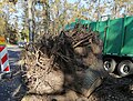 Ruhland, Kamenzer Straße (K6603), Sturm „Ignatz“, gestürzte Roteiche, Wurzelballen, 01.jpg 3,000 × 2,275; 1.52 MB
-
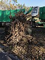
 Ruhland, Kamenzer Straße (K6603), Sturm „Ignatz“, gestürzte Roteiche, Wurzelballen, 02.jpg 3,000 × 2,253; 1.53 MB
-
 Ruhland, Kamenzer Straße (K6603), Sturm „Ignatz“, gestürzte Roteiche, Wurzelballen, 03.jpg 3,000 × 4,000; 5.62 MB
-
 Ruhland, Kamenzer Straße (K6603), Sturm „Ignatz“, gestürzte Roteiche, Wurzelballen, 04.jpg 3,000 × 4,000; 5.35 MB
-
 Ruhland, Ortrander Str. gegenüber Hausnr. 14d, Sturm „Ignatz“, Schaden an Roteiche, 01.jpg 3,000 × 4,000; 3.16 MB
-
-
 Ruhland, Ortrander Str. gegenüber Hausnr. 14d, Sturm „Ignatz“, Schaden an Roteiche, 03.jpg 2,529 × 3,930; 2.66 MB
-
 Ruhland, Ortrander Str. gegenüber Hausnr. 14d, Sturm „Ignatz“, Schaden an Roteiche, 04.jpg 2,184 × 3,974; 1.88 MB
-

-

-

-
 Wandbilder an der Trafostation Rudolf-Breitscheid-Str. in Ruhland, Südansicht.jpg 2,272 × 1,704; 459 KB
,_Roteichen-Allee,_gest%C3%BCrzte_Roteiche,_Sturm_%E2%80%9EIgnatz%E2%80%9C,_01.jpg)
,_Sturm_%E2%80%9EIgnatz%E2%80%9C,_gest%C3%BCrzte_Roteiche,_Wurzelballen,_01.jpg)
,_Sturm_%E2%80%9EIgnatz%E2%80%9C,_gest%C3%BCrzte_Roteiche,_Wurzelballen,_02.jpg)
,_Sturm_%E2%80%9EIgnatz%E2%80%9C,_gest%C3%BCrzte_Roteiche,_Wurzelballen,_03.jpg)
,_Sturm_%E2%80%9EIgnatz%E2%80%9C,_gest%C3%BCrzte_Roteiche,_Wurzelballen,_04.jpg)


