Category:Storeton Hall
Jump to navigation
Jump to search
| Object location | | View all coordinates using: OpenStreetMap |
|---|
This is a category about listed building number 1075385. |
|
This is a category about scheduled monument number 1004918. |
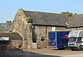
Grade II* listed former house, now farm building, in Storeton, Wirral, Merseyside, England, UK  | |||||
| Upload media | |||||
| Instance of | |||||
|---|---|---|---|---|---|
| Location | Wirral, Merseyside, North West England, England | ||||
| Heritage designation |
| ||||
 | |||||
Storeton Hall is a Grade II* listed former manor house, now a farm, dating to c. 1372. It is also a Scheduled Ancient Monument.
Media in category "Storeton Hall"
The following 3 files are in this category, out of 3 total.
-
 Entrance to Storeton Hall.jpg 5,018 × 3,058; 12.24 MB
-
 Storeton Hall 1.jpg 5,160 × 3,440; 15.02 MB
-
 Storeton Hall 2.jpg 4,644 × 3,220; 8.73 MB

