Category:Stoke Edith
Jump to navigation
Jump to search
village in Herefordshire, England, UK | |||||
| Upload media | |||||
| Instance of | |||||
|---|---|---|---|---|---|
| Location | Herefordshire, West Midlands, England | ||||
| Population |
| ||||
 | |||||
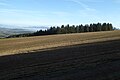
English: Stoke Edith is a village in the English county of Herefordshire, situated on a road leading from Hereford to Ledbury. The manor belonged to the Wallwynes, Milwaters and Lingen families. Once the principal manor of Sir Henry Lingen, it was sold to the Foley family in the 1670s. They rebuilt the house (Stoke Park), which was destroyed by fire in 1926. Stoke Edith House (once the Rectory), the park and extensive agricultural and woodlands remain in the ownership of the Foley family.

Subcategories
This category has the following 5 subcategories, out of 5 total.
O
- Oasts in Stoke Edith (1 F)
P
- Perton, Herefordshire (3 F)
S
- Stoke Edith House (14 F)
- Stoke Edith railway station (2 F)
Media in category "Stoke Edith"
The following 70 files are in this category, out of 70 total.
-

-
 Brick Wall by St. Mary the Virgin Church (Stoke Edith) - geograph.org.uk - 6166448.jpg 3,648 × 2,736; 4.7 MB
-
 Bridge over Footpath at Stoke Edith - geograph.org.uk - 2700661.jpg 2,256 × 1,496; 905 KB
-
 Churchyard at St. Mary the Virgin Church (Stoke Edith) - geograph.org.uk - 6166430.jpg 3,648 × 2,736; 4.93 MB
-

-
 East window, Stoke Edith church - geograph.org.uk - 5270486.jpg 768 × 1,024; 306 KB
-
 Entrance Gate to Stoke Edith House - geograph.org.uk - 6166483.jpg 3,648 × 2,736; 4.62 MB
-
 Farm Track with Asparagus field - geograph.org.uk - 2700621.jpg 2,256 × 1,496; 877 KB
-
 Farmland above Tarrington - geograph.org.uk - 5653532.jpg 1,024 × 683; 191 KB
-
 Field gateway - geograph.org.uk - 5653757.jpg 1,024 × 768; 344 KB
-
 Flowers at St. Mary the Virgin Church (Stoke Edith) - geograph.org.uk - 6166471.jpg 3,648 × 2,736; 4.6 MB
-
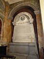
 Foley memorial tablet, Stoke Edith church - geograph.org.uk - 5272983.jpg 1,024 × 768; 165 KB
-
 Footbridge by Stoke Edith House - geograph.org.uk - 6166485.jpg 3,648 × 2,736; 4.72 MB
-
 Lane at Stoke Edith - geograph.org.uk - 6166486.jpg 3,648 × 2,736; 4.44 MB
-
 Lane by Stoke Edith House - geograph.org.uk - 6166484.jpg 3,648 × 2,736; 4.87 MB
-
 Ledbury Lodge, Stoke Edith Park (geograph 6691539).jpg 1,024 × 768; 276 KB
-
 Lodge and gates near Stoke Edith - geograph.org.uk - 5462137.jpg 640 × 495; 151 KB
-
 Lodge, Perton - geograph.org.uk - 5462139.jpg 640 × 508; 265 KB
-
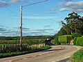 Main road, Perton - geograph.org.uk - 5463312.jpg 640 × 479; 153 KB
-
 Memorial effigy in Stoke Edith church - geograph.org.uk - 5270497.jpg 1,024 × 768; 155 KB
-

-
 Memorial effigy, Stoke Edith church - geograph.org.uk - 5270495.jpg 768 × 1,024; 178 KB
-
 Memorial in Stoke Edith church - geograph.org.uk - 5273329.jpg 576 × 1,024; 117 KB
-

-
 Memorial of Edward Foley (Stoke Edith) - geograph.org.uk - 6166819.jpg 4,096 × 5,461; 6.02 MB
-
 Memorial of Paul Foley (Stoke Edith) - geograph.org.uk - 6166355.jpg 2,736 × 3,648; 2.95 MB
-
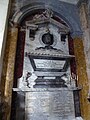
 Memorial to Edward Foley, Stoke Edith church - geograph.org.uk - 5272964.jpg 768 × 1,024; 194 KB
-

-
 Memorial to Lord Montagu - geograph.org.uk - 5273336.jpg 450 × 800; 79 KB
-

-
 Memorial to Paul Foley, Stoke Edith church - geograph.org.uk - 5272951.jpg 768 × 1,024; 194 KB
-
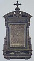
 Memorial to Tom Onslow, Stoke Edith church - geograph.org.uk - 5273287.jpg 768 × 1,024; 178 KB
-
 Muddy field entrance near Glebe Farm - geograph.org.uk - 4304009.jpg 800 × 451; 189 KB
-
 Oast House - geograph.org.uk - 3611835.jpg 427 × 640; 115 KB
-
 Path by St. Mary the Virgin Church (Stoke Edith) - geograph.org.uk - 6166444.jpg 3,648 × 2,736; 5.03 MB
-
 Plastic Plants - geograph.org.uk - 1349782.jpg 640 × 480; 188 KB
-
 Sheep pasture by Perton Lane - geograph.org.uk - 6018040.jpg 1,600 × 901; 626 KB
-
 Sign at St. Mary the Virgin Church (Stoke Edith) - geograph.org.uk - 6166270.jpg 3,648 × 2,736; 4.28 MB
-
 Signage by the entrance to Perton Quarry - geograph.org.uk - 6018035.jpg 1,600 × 901; 682 KB
-
 St Edith's well - geograph.org.uk - 552378.jpg 640 × 480; 101 KB
-
 St Mary the Virgin church, Stoke Edith - geograph.org.uk - 2700658.jpg 1,496 × 2,256; 887 KB
-
 St Mary, Stoke Edith - geograph.org.uk - 5462129.jpg 451 × 640; 118 KB
-
 St. Mary the Virgin Church (Altar ^ Stoke Edith) - geograph.org.uk - 6166364.jpg 3,648 × 2,736; 2.45 MB
-
 St. Mary the Virgin Church (Bell Tower ^ Stoke Edith) - geograph.org.uk - 6166323.jpg 2,048 × 2,730; 3.5 MB
-
 St. Mary the Virgin Church (Bell Tower ^ Stoke Edith) - geograph.org.uk - 6166327.jpg 2,736 × 3,648; 3.3 MB
-
 St. Mary the Virgin Church (Bell Tower ^ Stoke Edith) - geograph.org.uk - 6166328.jpg 3,648 × 2,736; 3.62 MB
-
 St. Mary the Virgin Church (Bell Tower ^ Stoke Edith) - geograph.org.uk - 6166437.jpg 2,736 × 3,648; 3.38 MB
-
 St. Mary the Virgin Church (Bell Tower ^ Stoke Edith) - geograph.org.uk - 6166441.jpg 2,736 × 3,648; 3.79 MB
-

-
 St. Mary the Virgin Church (Chancel ^ Stoke Edith) - geograph.org.uk - 6166370.jpg 3,648 × 2,736; 2.61 MB
-
 St. Mary the Virgin Church (Font ^ Stoke Edith) - geograph.org.uk - 6166417.jpg 3,648 × 2,736; 2.63 MB
-
 St. Mary the Virgin Church (Gallery ^ Stoke Edith) - geograph.org.uk - 6166427.jpg 3,648 × 2,736; 2.48 MB
-
 St. Mary the Virgin Church (Nave ^ Stoke Edith) - geograph.org.uk - 6166400.jpg 3,648 × 2,736; 2.62 MB
-
 St. Mary the Virgin Church (Pulpit ^ Stoke Edith) - geograph.org.uk - 6166368.jpg 3,648 × 2,736; 2.71 MB
-
 St. Mary the Virgin Church (Stoke Edith) - geograph.org.uk - 6166412.jpg 3,648 × 2,056; 2.22 MB
-
 St. Mary the Virgin Church (Stoke Edith) - geograph.org.uk - 6166481.jpg 3,648 × 2,736; 3.29 MB
-
 Stained glass windows, Stoke Edith church - geograph.org.uk - 5272928.jpg 768 × 1,024; 237 KB
-
 Stoke Edith church - geograph.org.uk - 5270455.jpg 768 × 1,024; 209 KB
-
 Stoke Edith church - geograph.org.uk - 5270458.jpg 600 × 800; 99 KB
-
 Stoke Edith church - geograph.org.uk - 5270461.jpg 768 × 1,024; 276 KB
-
 Stoke Edith House - geograph.org.uk - 6166480.jpg 3,648 × 2,736; 4.69 MB
-
 Stoke Edith Trading Estate - geograph.org.uk - 1349774.jpg 640 × 480; 135 KB
-
 Swillow Wood - geograph.org.uk - 5653529.jpg 1,024 × 683; 162 KB
-
 The nave of Stoke Edith church - geograph.org.uk - 5270469.jpg 1,024 × 768; 149 KB
-
 The Old Rectory (Stoke Edith) - geograph.org.uk - 6166453.jpg 3,648 × 2,736; 4.65 MB
-
 Trading estate at Stoke Edith - geograph.org.uk - 4304011.jpg 800 × 451; 149 KB
-
-
 Walls by Stoke Edith House - geograph.org.uk - 6166488.jpg 3,648 × 2,736; 3.86 MB
-
-
 Potato harvesting at Stoke Edith - geograph.org.uk - 67108.jpg 426 × 640; 75 KB

_-_geograph.org.uk_-_6166448.jpg)

_-_geograph.org.uk_-_6166430.jpg)
_-_geograph.org.uk_-_6166475.jpg)


_-_geograph.org.uk_-_6166471.jpg)


.jpg)


_-_geograph.org.uk_-_6166422.jpg)


_-_geograph.org.uk_-_6166374.jpg)
_-_geograph.org.uk_-_6166819.jpg)
_-_geograph.org.uk_-_6166355.jpg)


_-_geograph.org.uk_-_6166444.jpg)


_-_geograph.org.uk_-_6166270.jpg)


_-_geograph.org.uk_-_6166364.jpg)
_-_geograph.org.uk_-_6166323.jpg)
_-_geograph.org.uk_-_6166327.jpg)
_-_geograph.org.uk_-_6166328.jpg)
_-_geograph.org.uk_-_6166437.jpg)
_-_geograph.org.uk_-_6166441.jpg)
_-_geograph.org.uk_-_6166472.jpg)
_-_geograph.org.uk_-_6166370.jpg)
_-_geograph.org.uk_-_6166417.jpg)
_-_geograph.org.uk_-_6166427.jpg)
_-_geograph.org.uk_-_6166400.jpg)
_-_geograph.org.uk_-_6166368.jpg)
_-_geograph.org.uk_-_6166412.jpg)
_-_geograph.org.uk_-_6166481.jpg)


_-_geograph.org.uk_-_6166453.jpg)

_-_geograph.org.uk_-_6166382.jpg)

_-_geograph.org.uk_-_6166343.jpg)
