Category:Stoanglerhöhe
Jump to navigation
Jump to search
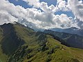
Deutsch: Stongenhöhe (auch: Stongerhöhe, Stoanglerhöhe) - Berg (1778 m.ü.M.) im Bregenzerwald in der Gemeinde Andelsbuch und Egg, Vorarlberg, Österreich.
English: Stongenhoehe (also: Stongerhoehe, Stoanglerhoehe) - Mountain (1778 masl) in the Bregenzerwald (Bregenz Forest) in the community of Andelsbuch and Egg, Vorarlberg, Austria.
Français : Stongenhöhe (aussi: Stongerhöhe, Stoanglerhöhe) - Montagne (1778 mètres d'altitude) dans la Bregenzerwald (Forêt de Bregenz) dans la communauté de Andelsbuch et Egg, Vorarlberg, Autriche.
| Object location | | View all coordinates using: OpenStreetMap |
|---|
mountain between the municipalities of Egg and Andelsbuch in Vorarlberg, Austria  | |||||
| Upload media | |||||
| Instance of | |||||
|---|---|---|---|---|---|
| Location |
| ||||
 | |||||
Media in category "Stoanglerhöhe"
The following 8 files are in this category, out of 8 total.
-
 Andelsbuch-Alpe Stoangerhoehe-Stoanglerhoehe-02ASD.jpg 4,592 × 3,056; 5.13 MB
-

-

-
-
 Andelsbuch-Niedere-Tristenkopf-Stoanglerhöhe-Winterstaude-Sienspitz-Luguntenkopf-01ASD.jpg 4,592 × 3,056; 5.78 MB
-
 Andelsbuch-Niedere-Tristenkopf-Stoanglerhöhe-Winterstaude-Sienspitz-Luguntenkopf-02ASD.jpg 4,385 × 2,920; 1.28 MB
-
 Andelsbuch-Niedere-Tristenkopf-Stoanglerhöhe-Winterstaude-Sienspitz-Luguntenkopf-03ASD.jpg 4,392 × 2,942; 1.38 MB
-
 Andelsbuch-Tristenkopf-Stoanglerhöhe-Winterstaude-06ASD.jpg 4,345 × 2,876; 1.16 MB


