Category:Stift Olsberg
Jump to navigation
Jump to search
| Object location | | View all coordinates using: OpenStreetMap |
|---|
church buildings in Olsberg in the canton of Aargau, Switzerland  | |||||
| Upload media | |||||
| Instance of | |||||
|---|---|---|---|---|---|
| Part of | |||||
| Location | Olsberg, Rheinfelden District, Aargau, Switzerland | ||||
| Street address |
| ||||
| Heritage designation | |||||
 | |||||
Media in category "Stift Olsberg"
The following 14 files are in this category, out of 14 total.
-
 Deo Atque Virgini.jpg 3,072 × 2,304; 1.33 MB
-
 Kirche Olsberg ganz.jpg 3,072 × 2,304; 1.28 MB
-
 Kirche Olsberg.jpg 2,304 × 3,072; 1.31 MB
-
 Kloster Olsberg 1.jpg 486 × 678; 189 KB
-
 Kloster Olsberg 2.jpg 571 × 393; 57 KB
-
 Olsberg kirche.jpg 870 × 600; 305 KB
-
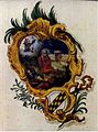 Olsberg Titelblatt.jpg 520 × 702; 42 KB
-
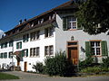 Ritterhaus und Pfarrhaus.jpg 3,072 × 2,304; 1.66 MB
-
 Schild Pestalozzistiftung Olsberg.jpg 2,869 × 2,002; 1.06 MB
-
 Statue in Kirchenfassade.jpg 2,304 × 3,072; 922 KB
-
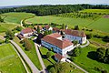 Stift Olsberg (Switzerland).jpg 4,000 × 2,666; 5.03 MB
-
 Stift Olsberg, Kanton Aargau.jpg 800 × 600; 198 KB
-
 Stift Olsberg.jpg 998 × 592; 244 KB
-
 Wappen auf Kirche.jpg 1,409 × 1,870; 363 KB


.jpg)


