Category:Steinkreuz Wirbertshofen
Jump to navigation
Jump to search
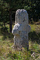
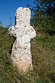
This is the category of the Bavarian Baudenkmal (cultural heritage monument) with the ID D-3-73-112-211 (Wikidata)
|
| Object location | | View all coordinates using: OpenStreetMap |
|---|
Deutsch: Sühnekreuz, mittelalterlich. Kalkstein
 | |||||
| Upload media | |||||
| Instance of | |||||
|---|---|---|---|---|---|
| Made from material | |||||
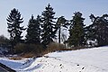
| Location | Wirbertshofen, Berching, Neumarkt, Upper Palatinate, Bavaria, Germany | ||||
| Street address |
| ||||
| Heritage designation | |||||
| Width |
| ||||
| Length |
| ||||
| Height |
| ||||
| official website | |||||
 | |||||
Media in category "Steinkreuz Wirbertshofen"
The following 11 files are in this category, out of 11 total.
-
 D-3-73-112-211 01.jpg 3,456 × 2,304; 3.02 MB
-
 D-3-73-112-211 02.jpg 2,304 × 3,456; 2.57 MB
-
 D-3-73-112-211 03.jpg 2,304 × 3,456; 2.89 MB
-
 D-3-73-112-211 04.jpg 2,304 × 3,456; 2.39 MB
-
 Steinkreuz Wirbertshofen -000.JPG 4,000 × 6,000; 6.56 MB
-
 Steinkreuz Wirbertshofen -001.JPG 4,000 × 6,000; 5.93 MB
-
 Steinkreuz Wirbertshofen -002.JPG 6,000 × 4,000; 7.22 MB
-
 Steinkreuz Wirbertshofen -003.JPG 4,000 × 6,000; 6.76 MB
-
 Steinkreuz Wirbertshofen -004.JPG 4,000 × 6,000; 6.09 MB
-
 Steinkreuz Wirbertshofen -005.JPG 4,000 × 6,000; 6.72 MB
-
 Steinkreuz Wirbertshofen -006.JPG 6,000 × 4,000; 8 MB


