Category:Steinkreuz Neumarkt Badstraße
Jump to navigation
Jump to search
This is the category of the Bavarian Baudenkmal (cultural heritage monument) with the ID D-3-73-147-29 (Wikidata)
|
| Object location | | View all coordinates using: OpenStreetMap |
|---|
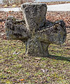
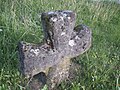
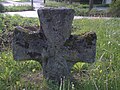
Deutsch: An der Einmündung der Mariahilfstraße in die Badstraße befindet sich in der Oberpfälzer Kreisstadt Neumarkt ein Steinkreuz.
 | |||||
| Upload media | |||||
| Instance of | |||||
|---|---|---|---|---|---|
| Made from material | |||||
| Location | Neumarkt in der Oberpfalz, Neumarkt, Upper Palatinate, Bavaria, Germany | ||||
| Street address |
| ||||
| Heritage designation | |||||
| Width |
| ||||
| Length |
| ||||
| Height |
| ||||
| official website | |||||
 | |||||
Media in category "Steinkreuz Neumarkt Badstraße"
The following 8 files are in this category, out of 8 total.
-
 D-3-73-147-29 01.jpg 2,711 × 3,242; 2.07 MB
-
 D-3-73-147-29 02.jpg 4,118 × 2,880; 3.42 MB
-
 D-3-73-147-29 03.jpg 3,159 × 3,804; 3.13 MB
-
 D-3-73-147-29 04.jpg 3,159 × 4,423; 3.02 MB
-
 D-3-73-147-29 05.jpg 5,012 × 3,341; 3.09 MB
-
 Steinkreuz Neumarkt Badstraße 01.jpg 3,664 × 2,742; 2.76 MB
-
 Steinkreuz Neumarkt Badstraße 02.jpg 3,664 × 2,742; 2.34 MB
-
 Steinkreuz Neumarkt Badstraße 03.jpg 3,664 × 2,742; 2.82 MB


