Category:Stations of the Cross to Maria Loreto (Starý Hrozňatov)

1. Kreuzweg-Station (zerstört), an der Straße Podhrad - Kozly, bei Nový Hrozňatov: Jesus tritt den Leidensweg an - Abschied von seiner Mutter / Ježíš se loučí s Marií, siehe auch [4]
| Object location | | View all coordinates using: OpenStreetMap |
|---|
2. Kreuzweg-Station (zerstört): Jesus betet am Ölberg / Ježíš se modlí
| Object location | | View all coordinates using: OpenStreetMap |
|---|
3. Kreuzweg-Station (zerstört): Jesus wird von einem Engel / Ježíš je posilován od anděla gestärkt
4. Kreuzweg-Station (zerstört): Jesus wird von Judas verraten / Ježíš je zrazen a zajat
5. Kreuzweg-Station: Jesus wird gefangen genommen / Ježíš je mučen, siehe [5]
| Object location | | View all coordinates using: OpenStreetMap |
|---|
6. Kreuzweg-Station: Jesus wird zum Bach Cedron geschleppt / Ježíše vlečou potokem Cedron, siehe [6]
| Object location | | View all coordinates using: OpenStreetMap |
|---|
7. Kreuzweg-Station (zerstört): Jesus vor dem Hohenpriester Hannas, er empfängt einen Backenstreich / Ježíš před knězem Annášem
8. Kreuzweg-Station: Jesus wird vom Hohenpriester Kaiphas angeklagt / Ježíš je obžalován
| Object location | | View all coordinates using: OpenStreetMap |
|---|
9. Kreuzweg-Station (Dreifaltigkeitskapelle): Jesus hält mit seinen Jüngern das letzte Abendmahl / Poslední večeře Páně
| Object location | | View all coordinates using: OpenStreetMap |
|---|
10. Kreuzweg-Station (zerstört): Herodes verachtet Jesus / Herodes posílá Ježíše k Pilátovi
| Object location | | View all coordinates using: OpenStreetMap |
|---|
11. Kreuzweg-Station (zerstört): Jesus wird in das Haus des Pilatus geführt / Ježíš je předveden k Pilátovi
12. Kreuzweg-Station (zerstört): Jesus wird ausgepeitscht / Ježíš je bičován
13. Kreuzweg-Station (zerstört): Jesus wird bewußtlos / Ježíš upadá v bezvědomí
14. Kreuzweg-Station (zerstört): Jesus wird mit der Dornenkrone gekrönt / Ježíš je korunován trním
15. Kreuzweg-Station (zerstört): Jesus wird von Pilatus dem Volk vorgestellt (Ecce homo) / Pilát říká: Ecce homo!
16. Kreuzweg-Station (zerstört): Jesus wird auf Drängen des Volkes zum Tode verurteilt / Ježíš je odsouzen k smrti
11. bis 16. Station: Pilatus-Haus, siehe [7]
| Object location | | View all coordinates using: OpenStreetMap |
|---|
17. Kreuzweg-Station (zerstört): Jesus nimmt das Kreuz auf seine Schultern / Ježíš bere kříž
18. Kreuzweg-Station (zerstört): Jesus fällt unter der Last des Kreuzes / Ježíš padá pod křížem
19. Kreuzweg-Station (zerstört): Jesus fällt zum zweiten Male unter dem Kreuz, Simon hilft das Kreuz tragen / Šimon pomáhá nést kříž
20. Kreuzweg-Station (zerstört): Jesus begegnet seiner lieben Mutter / Ježíš potkává svou matku
| Object location | | View all coordinates using: OpenStreetMap |
|---|
21. Kreuzweg-Station (zerstört): Veronika reicht Jesus das Schweißtuch / Veronika podává Ježíši roušku
| Object location | | View all coordinates using: OpenStreetMap |
|---|
22. Kreuzweg-Station (zerstört): Jesus wird durch das Tor von Jerusalem zum Kalvarienberg geführt / Ježíš je veden bránou na Golgotu, siehe [8]
| Object location | | View all coordinates using: OpenStreetMap |
|---|
23. Kreuzweg-Station: Die Töchter Jerusalems weinen um Jesus / Ženy pláčí nad Ježíšem
| Object location | | View all coordinates using: OpenStreetMap |
|---|
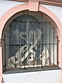
24. Kreuzweg-Station: Jesus fällt zum dritten Mal unter dem Kreuz / Ježíš padá pod křížem po třetí
| Object location | | View all coordinates using: OpenStreetMap |
|---|
25. Kreuzweg-Station: Die Henkersknechte entblößen ihn / Pacholci strhávají Ježíši šat
| Object location | | View all coordinates using: OpenStreetMap |
|---|
26. Kreuzweg-Station: Jesus wird ans Kreuz genagelt / Ježíš je přibíjen na kříž
| Object location | | View all coordinates using: OpenStreetMap |
|---|
27. Kreuzweg-Station (Kreuzkapelle): Jesus stirbt am Kreuz / Ježíš umírá na kříži
| Object location | | View all coordinates using: OpenStreetMap |
|---|
28. Kreuzweg-Station: Jesus wird vom Kreuz abgenommen / Ježíšovo tělo je sejmuto z kříže
| Object location | | View all coordinates using: OpenStreetMap |
|---|
29. Kreuzweg-Station (Heiliges Grab): Der Leichnam Jesu wird ins Grab gelegt / Ježíšovo tělo je vloženo do hrobu
| Object location | | View all coordinates using: OpenStreetMap |
|---|
 | |||||
| Upload media | |||||
| Instance of | |||||
|---|---|---|---|---|---|
| Location | Loreto chapel in Starý Hrozňatov, Starý Hrozňatov, Cheb, Cheb District, Karlovy Vary Region, Czechia | ||||
| Has part(s) | |||||
 | |||||
Subcategories
This category has the following 2 subcategories, out of 2 total.
Media in category "Stations of the Cross to Maria Loreto (Starý Hrozňatov)"
The following 20 files are in this category, out of 20 total.
-
 Altkinsberg-Loreto-Karte.jpg 827 × 832; 435 KB
-
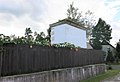
 Kaple svatého Kříže u areálu Maria Loreto v Hrozňatově (Q104983925).jpg 1,200 × 799; 144 KB
-
-

-
-

-

-

-

-

-
-
-

-
-
 Maria Loreto 24. Kreuzwegstation.jpg 3,243 × 2,556; 4.11 MB
-
 Poutní místo Maria Loreto kaple svatého Kříže červen 2023 (1).jpg 5,770 × 3,847; 9.63 MB
-
 Poutní místo Maria Loreto křížová cesta červen 2023 (1).jpg 3,845 × 5,768; 9.49 MB
-
 Poutní místo Maria Loreto křížová cesta červen 2023 (2).jpg 5,645 × 3,764; 7.18 MB
-
 Poutní místo Maria Loreto křížová cesta červen 2023 (3).jpg 3,866 × 5,798; 7.68 MB
-
 Poutní místo Maria Loreto křížová cesta červenec 2023 (1).jpg 4,000 × 6,000; 9.41 MB
.jpg)
_01.jpg)
_02.jpg)
_01.jpg)
_02.jpg)
_01.jpg)
_02.jpg)
_01.jpg)
_02.jpg)
_01.jpg)
_02.jpg)
_01.jpg)
_02.jpg)

.jpg)
.jpg)
.jpg)
.jpg)
.jpg)