Category:Statenzaal (Dordrecht)
Jump to navigation
Jump to search
| Object location | | View all coordinates using: OpenStreetMap |
|---|
 | |||||
| Upload media | |||||
| Instance of | |||||
|---|---|---|---|---|---|
| Location | Dordrecht, South Holland, Netherlands | ||||
| Street address |
| ||||
| Located on street |
| ||||
| Heritage designation |
| ||||
 | |||||
|
This is a category about rijksmonument number 13438
|
| Address |
|
Media in category "Statenzaal (Dordrecht)"
The following 34 files are in this category, out of 34 total.
-
 13438 Statenzaal Dordrecht.jpg 3,000 × 2,212; 6.35 MB
-
 Augustijnenkamp, 3311 Dordrecht, Netherlands - panoramio (8).jpg 4,896 × 3,264; 3.34 MB
-
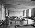
 Building-hof10.jpg 640 × 480; 91 KB
-
 De achtergevel van de Statenzaal - Dordrecht - 20062089 - RCE.jpg 955 × 1,200; 323 KB
-
 De achtergevel van de Statenzaal - Dordrecht - 20062090 - RCE.jpg 965 × 1,200; 337 KB
-
 De Statenzaal in de steigers, de noordoostzijde - Dordrecht - 20062103 - RCE.jpg 788 × 1,200; 204 KB
-

-
Dordrecht - Hof.ogv 23 s, 1,280 × 720; 19.92 MB
-
 Dordrecht Statenzaal 018 0304.jpg 6,000 × 3,856; 19.67 MB
-
 Dordrecht Statenzaal 018 0307.jpg 11,118 × 6,048; 51.04 MB
-
 Dordrecht Statenzaal.jpg 4,000 × 6,000; 18.12 MB
-
 Gebouw der Statenzaal bekapping - Dordrecht - 20061478 - RCE.jpg 1,200 × 946; 229 KB
-
 Gebouw der Statenzaal bovenzaal - Dordrecht - 20061477 - RCE.jpg 1,200 × 949; 194 KB
-

-

-
 Gebouw der Statenzaal exterieur naar het oosten - Dordrecht - 20061481 - RCE.jpg 1,200 × 952; 243 KB
-
 Gebouw der Statenzaal kraagsteen in trappenhuis - Dordrecht - 20061483 - RCE.jpg 1,200 × 955; 194 KB
-
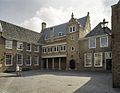
 Hof10.jpg 3,888 × 2,592; 9.32 MB
-
 Interieur hal voor de Statenzaal op de begane grond - Dordrecht - 20061603 - RCE.jpg 1,200 × 1,200; 203 KB
-
 Interieur hal voor de Statenzaal op de begane grond - Dordrecht - 20061604 - RCE.jpg 1,190 × 1,200; 215 KB
-
 Overzicht Statenzaal - Dordrecht - 20376956 - RCE.jpg 1,200 × 927; 270 KB
-
 Statenzaal "Vuurplaat" - Dordrecht - 20061577 - RCE.jpg 1,200 × 955; 416 KB
-
 Statenzaal - Dordrecht - 20061578 - RCE.jpg 1,200 × 1,191; 456 KB
-
 Statenzaal - Dordrecht - 20061579 - RCE.jpg 1,200 × 1,190; 364 KB
-
 Statenzaal - Dordrecht - 20061580 - RCE.jpg 1,188 × 1,200; 427 KB
-
 Statenzaal - Dordrecht - 20061581 - RCE.jpg 1,197 × 1,200; 397 KB
-
 Statenzaal - Dordrecht - 20061582 - RCE.jpg 1,200 × 1,147; 410 KB
-
 Statenzaal - Dordrecht - 20061583 - RCE.jpg 1,200 × 1,188; 420 KB
-
 Statenzaal - Dordrecht - 20061584 - RCE.jpg 1,179 × 1,200; 426 KB
-
 Statenzaal van het Hof te Dordrecht.jpg 1,020 × 660; 189 KB
-
 Statenzaal, glas in loodraam - Dordrecht - 20061597 - RCE.jpg 1,197 × 1,200; 260 KB
-
 Statenzaal, glas in loodraam - Dordrecht - 20061598 - RCE.jpg 1,196 × 1,200; 265 KB
-
 Statenzaal, glas in loodraam - Dordrecht - 20061599 - RCE.jpg 1,197 × 1,200; 255 KB
-
 Statenzaal, Glas in loodraam zwart-wit - Dordrecht - 20061594 - RCE.jpg 1,197 × 1,200; 207 KB

.jpg)


