Category:Stantenwegtrotte
Jump to navigation
Jump to search
| Object location | | View all coordinates using: OpenStreetMap |
|---|
 | |||||
| Upload media | |||||
| Instance of | |||||
|---|---|---|---|---|---|
| Part of | |||||
| Location |
| ||||
| Street address |
| ||||
| Heritage designation | |||||
 | |||||
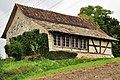
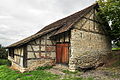
Media in category "Stantenwegtrotte"
The following 11 files are in this category, out of 11 total.
-
 Flurlingen - Sogenannte Stantenwegtrotte, Stanten-Weg 2011-09-19 14-35-56.jpg 4,000 × 2,667; 4.08 MB
-
 Flurlingen - Sogenannte Stantenwegtrotte, Stanten-Weg 2011-09-19 14-36-40.jpg 4,000 × 2,667; 3.22 MB
-
 Flurlingen - Sogenannte Stantenwegtrotte, Stanten-Weg 2011-09-19 14-36-52.jpg 4,000 × 2,667; 4.23 MB
-
 Flurlingen - Sogenannte Stantenwegtrotte, Stanten-Weg 2011-09-19 14-37-24.jpg 2,454 × 3,681; 3.41 MB
-
 Flurlingen - Sogenannte Stantenwegtrotte, Stanten-Weg 2011-09-19 14-37-48.JPG 4,288 × 2,848; 3.61 MB
-
 Flurlingen - Sogenannte Stantenwegtrotte, Stanten-Weg 2011-09-19 14-38-18.JPG 4,000 × 2,665; 3.5 MB
-
 Flurlingen - Sogenannte Stantenwegtrotte, Stanten-Weg 2011-09-19 14-38-44 ShiftN.jpg 3,814 × 2,543; 3.06 MB
-
 Flurlingen - Sogenannte Stantenwegtrotte, Stanten-Weg 2011-09-19 14-38-52.JPG 3,976 × 2,640; 3.95 MB
-
 Flurlingen - Sogenannte Stantenwegtrotte, Stanten-Weg 2011-09-19 14-39-24.JPG 4,288 × 2,848; 4.65 MB
-
 Flurlingen - Sogenannte Stantenwegtrotte, Stanten-Weg 2011-09-19 14-39-48.JPG 4,288 × 2,848; 4.41 MB
-
 Sogenannte Stantenwegtrotte, Stanten-Weg in Flurlingen 2011-09-19 14-37-08 ShiftN.jpg 4,000 × 2,667; 3.5 MB


