Category:Stanley Wood
Jump to navigation
Jump to search
| Object location | | View all coordinates using: OpenStreetMap |
|---|
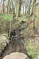
A woodland to the north of Brickfields Farm and south of Landican Lane.
Media in category "Stanley Wood"
The following 4 files are in this category, out of 4 total.
-
 Brickfields Farm 2.jpg 5,104 × 3,268; 15.94 MB
-
 Clearing, Stanley Wood.jpg 5,209 × 3,242; 19.04 MB
-
 Dirt road, Stanley Wood.jpg 5,022 × 3,203; 19.53 MB
-
 Storeton tributary of Prenton Brook 4.jpg 3,456 × 5,165; 21.58 MB


