Category:Stamford Hill (street)
Jump to navigation
Jump to search
street in the London Borough of Hackney _-_geograph.org.uk_-_169793.jpg) | |||||
| Upload media | |||||
| Instance of | |||||
|---|---|---|---|---|---|
| Part of | |||||
| Location | London Borough of Hackney, Greater London, London, England | ||||
| Connects with | |||||
 | |||||
Subcategories
This category has only the following subcategory.
S
- Stoke Newington railway station (33 F)
Media in category "Stamford Hill (street)"
The following 17 files are in this category, out of 17 total.
-
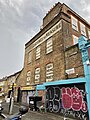 266 and 268 Stamford Hill, Tottenham, August 2023.jpg 3,024 × 4,032; 4.79 MB
-
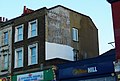
 A The Dainty Shops 78-80 Stamford Hill N16 toh shop.jpg 1,658 × 1,241; 1.36 MB
-
 A10, Stoke Newington - geograph.org.uk - 5366106.jpg 640 × 426; 76 KB
-
 A10, Stoke Newington - geograph.org.uk - 5366114.jpg 640 × 426; 61 KB
-
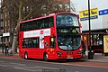
 Arriva London bus HV81 (LJ62 BJX) at Lynmouth Road stop, Stamford Hill, 27 April 2013.jpg 5,184 × 3,456; 6.25 MB
-
 Former Turnpike House pub, Ravensdale Road, Tottenham, August 2023.jpg 4,032 × 3,024; 4.62 MB
-
 Hat shop Stamford Hill, Hackney.jpg 3,008 × 2,000; 3.83 MB
-
 Kinh Do Vietnamese and Chinese take-away N16.jpg 2,448 × 3,264; 1.51 MB
-
 London General bus WVN29 (BG59 FXF) at Lynmouth Road stop, Stamford Hill, 27 April 2013.jpg 5,184 × 3,456; 6.55 MB
-
 Pavement in Stamford Hill - geograph.org.uk - 391184.jpg 640 × 480; 116 KB
-
 Stamford Hill 2020.jpg 2,736 × 1,366; 1.51 MB
-
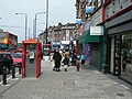 Stamford Hill N16 (1) - geograph.org.uk - 169793.jpg 640 × 480; 119 KB
-
 Stamford Hill N16 (2) - geograph.org.uk - 169796.jpg 640 × 480; 121 KB
-
 Stamford Hill, London N16 - geograph.org.uk - 2763413.jpg 4,320 × 3,240; 4.42 MB
-

-
 Turnpike House, Stamford Hill, N16 (7439052264).jpg 2,856 × 1,904; 2.82 MB
-
 Westminster Gazette.jpg 2,657 × 1,798; 1.77 MB


_at_Lynmouth_Road_stop,_Stamford_Hill,_27_April_2013.jpg)


_at_Lynmouth_Road_stop,_Stamford_Hill,_27_April_2013.jpg)


_-_geograph.org.uk_-_169796.jpg)


.jpg)
