Category:Stadtkirche Lauta
Jump to navigation
Jump to search
| Object location | | View all coordinates using: OpenStreetMap |
|---|
 | |||||
| Upload media | |||||
| Instance of | |||||
|---|---|---|---|---|---|
| Location |
| ||||
| Heritage designation | |||||
 | |||||
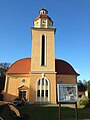
Deutsch: Die Stadtkirche in Lauta, am 4. Advent 1924 eingeweiht und war von 2012 bis 2016 wegen Baufälligkeit geschlossen.
Media in category "Stadtkirche Lauta"
The following 5 files are in this category, out of 5 total.
-
 Ev. Kulturkirche Lauta.jpg 2,448 × 3,264; 1.27 MB
-
 Evangelische Kirche Lauta-Stadt.JPG 1,920 × 2,560; 3.06 MB
-
 Kirche Lauta August 2017.jpg 3,648 × 5,472; 4.22 MB
-
 Stadtk. lauta.JPG 1,944 × 2,592; 1.06 MB
-
 Stadtkirche lauta.JPG 1,944 × 2,592; 1.11 MB


