Category:Stade Charles-Mathon
Jump to navigation
Jump to search
| Object location | | View all coordinates using: OpenStreetMap |
|---|
|
Stade Charles-Mathon has an entry on OpenStreetMap (show). |
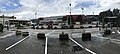
sports stadium in Oyonnax, France  | |||||
| Upload media | |||||
| Instance of | |||||
|---|---|---|---|---|---|
| Location | Oyonnax, Ain, Auvergne-Rhône-Alpes, Metropolitan France, France | ||||
| Street address |
| ||||
| Owned by | |||||
| Occupant | |||||
| Inception |
| ||||
| Date of official opening |
| ||||
| Maximum capacity |
| ||||
 | |||||
Subcategories
This category has only the following subcategory.
Media in category "Stade Charles-Mathon"
The following 12 files are in this category, out of 12 total.
-
 Grandstand Charles Mathon- soon the start of Ultra 01.jpg 2,592 × 1,944; 2.09 MB
-
 Oyonnax - août 2017 - 0.JPG 8,372 × 3,788; 8.03 MB
-
 Panneau Stade Charles-Mathon.JPG 4,928 × 1,859; 1.93 MB
-
 Sortie du stade Charles Mathon.jpg 3,264 × 2,448; 2.64 MB
-
 Stade Charles Mathon Oyonnax.jpg 960 × 720; 109 KB
-
 Stade Charles Mathon à Oyonnax.jpg 10,722 × 3,096; 9.32 MB
-
 Stade Charles-Mathon (Oyonnax) en août 2017.jpg 4,032 × 3,024; 2.99 MB
-
 Stade Charles-Mathon à Oyonnax en août 2017.jpg 3,024 × 4,032; 2.3 MB
-
 Stade Mathon - tribune.jpg 1,920 × 1,080; 295 KB
-
 Stade Mathon-entree.jpg 2,720 × 2,048; 1.88 MB
-
 Tour de l'Ain 2017 - Stage 3 (Oyonnax) - 1.JPG 4,032 × 3,024; 3.24 MB
-
 USO-AB - 20131221 - Stade Charles-Mathon.jpg 4,699 × 3,112; 12.73 MB


_en_ao%C3%BBt_2017.jpg)


_-_1.JPG)
