Category:St Thomas's Church, Wednesfield
Jump to navigation
Jump to search
| Object location | | View all coordinates using: OpenStreetMap |
|---|
Anglican church in Wednesfield, Wolverhampton, England  | |||||
| Upload media | |||||
| Instance of | |||||
|---|---|---|---|---|---|
| Dedicated to | |||||
| Location | City of Wolverhampton, West Midlands, England | ||||
| Street address |
| ||||
| Diocese | |||||
| Heritage designation |
| ||||
| Religion or worldview | |||||
| official website | |||||
 | |||||
Media in category "St Thomas's Church, Wednesfield"
The following 4 files are in this category, out of 4 total.
-
 St Thomas's Church, Christmas Day 2008 - geograph.org.uk - 1090756.jpg 480 × 640; 294 KB
-
 St Thomas's Church, Xmas Day 2007 - geograph.org.uk - 639891.jpg 640 × 480; 216 KB
-
 Wednesfield Library and Church - geograph.org.uk - 232331.jpg 640 × 480; 268 KB
-
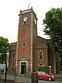 Wolverhampton Wednesfield St Thomas.JPG 3,000 × 4,000; 5.09 MB


