Category:St Philipp & St James, Holywood
Jump to navigation
Jump to search
| Object location | | View all coordinates using: OpenStreetMap |
|---|
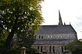
church building in Holywood, County Down, Northern Ireland  | |||||
| Upload media | |||||
| Instance of | |||||
|---|---|---|---|---|---|
| Location | Holywood, County Down, Northern Ireland | ||||
| Street address |
| ||||
| Heritage designation | |||||
| Inception |
| ||||
 | |||||
Media in category "St Philipp & St James, Holywood"
The following 2 files are in this category, out of 2 total.
-
 Holywood Parish Church of Ireland.jpg 4,928 × 3,264; 6.62 MB
-
 HOLYWOOD, St Philip and St James interior (47541633511).jpg 845 × 605; 148 KB
.jpg)