Category:St Matthew's Church, Clubmoor
Jump to navigation
Jump to search
| Object location | | View all coordinates using: OpenStreetMap |
|---|
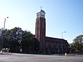
grade II listed church in Liverpool, Merseyside, England, UK  | |||||
| Upload media | |||||
| Instance of | |||||
|---|---|---|---|---|---|
| Location |
| ||||
| Heritage designation |
| ||||
 | |||||
Subcategories
This category has the following 3 subcategories, out of 3 total.
Media in category "St Matthew's Church, Clubmoor"
The following 8 files are in this category, out of 8 total.
-

-

-
 Door of St Matthew, Clubmoor.jpg 3,132 × 5,182; 22.66 MB
-

-
 St Matthew's Church, Clubmoor.jpg 1,600 × 1,198; 303 KB
-
 St Matthew's, Clubmoor (1).JPG 4,320 × 3,240; 2.47 MB
-
 St Matthew's, Clubmoor (2).JPG 4,320 × 3,240; 2.6 MB
-
 St Matthew's, Clubmoor 2020.jpg 3,757 × 2,887; 14.55 MB


.JPG)
.JPG)
Categories:
- 1930s brick churches in England
- 20th-century churches in Merseyside
- Queens Drive, Liverpool
- Brick churches in Merseyside
- Churches in England built in 1930
- Clubmoor
- Grade II listed churches in Liverpool
- Roman Catholic churches in Liverpool
- Saint Matthew churches in Merseyside
- F. X. Velarde
- Churches by Ernest Bower Norris