Category:St Mary Church, Westley Waterless
Jump to navigation
Jump to search
| Object location | | View all coordinates using: OpenStreetMap |
|---|
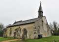
church in East Cambridgeshire, England, UK  | |||||
| Upload media | |||||
| Instance of | |||||
|---|---|---|---|---|---|
| Location | Westley Waterless, East Cambridgeshire, Cambridgeshire, East of England, England | ||||
| Diocese | |||||
| Heritage designation |
| ||||
| Religion or worldview | |||||
 | |||||
Media in category "St Mary Church, Westley Waterless"
The following 9 files are in this category, out of 9 total.
-
 St Mary the Less, Westley Waterless.jpg 427 × 640; 51 KB
-

-
 Westley Waterless St Mary eastward GeoUK 6021183.jpg 7,221 × 4,814; 5.7 MB
-
 Westley Waterless St Mary from NW GeoUK 6021180.jpg 5,414 × 3,886; 3.32 MB
-
 Westley Waterless St Mary nave & south aisle GeoUK 6021185.jpg 7,710 × 5,140; 7.06 MB
-
 Westley Waterless St Mary westward GeoUK 6021578.jpg 8,007 × 5,337; 6.34 MB
-
 Westley Waterless, St Mary the Less - geograph.org.uk - 3276182.jpg 1,022 × 1,024; 344 KB
-
 Westley Waterless, St. Mary the Less Church (geograph 6021180).jpg 6,131 × 4,088; 4.15 MB
-
 WestleyWaterless St Mary from NW GeoUK 6021180.png 1,952 × 1,400; 2.66 MB


.jpg)

Categories:
- 13th-century churches in Cambridgeshire
- Anglican churches in Cambridgeshire
- Churches in the Deanery of Fordham and Quy
- Flint churches in Cambridgeshire
- Grade II* listed churches in Cambridgeshire
- Saint Mary churches in Cambridgeshire
- Westley Waterless
- 14th-century churches in Cambridgeshire
- Gothic churches in Cambridgeshire
- Hall churches in Cambridgeshire