Category:St John's C. o. I., Limerick
Jump to navigation
Jump to search

|
This object is indexed in the Archaeological Survey of Ireland under SMR No. LI005-017041-
Geographic information system of the National Monuments Service: Historic Environment Viewer – Database record. |
|
|
This object is indexed in the National Inventory of Architectural Heritage of Ireland under the registration number 21513039
Geographic information system of the National Monuments Service: Historic Environment Viewer – Main record. |
| Object location | | View all coordinates using: OpenStreetMap |
|---|
Media in category "St John's C. o. I., Limerick"
This category contains only the following file.
-
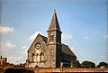 John's Sq Limerick 1982.jpg 1,000 × 674; 108 KB

Categories:
- Objects of County Limerick recorded in the Archaeological Survey of Ireland with known IDs
- Objects of County Limerick recorded in the National Inventory of Architecture of Ireland with known IDs
- Churches in Limerick
- Church of Ireland church buildings in County Limerick
- 1850s churches in Ireland
- Romanesque Revival churches in Ireland
- Architectural basilicas in Ireland