Category:St Georgenkapelle (Templin)
Jump to navigation
Jump to search
| Object location | | View all coordinates using: OpenStreetMap |
|---|
church 2.JPG) | |||||
| Upload media | |||||
| Instance of | |||||
|---|---|---|---|---|---|
| Made from material | |||||
| Location | Templin, Uckermark District, Brandenburg, Germany | ||||
| Architectural style | |||||
| Heritage designation | |||||
| Inception |
| ||||
 | |||||
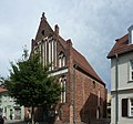
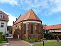
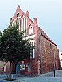
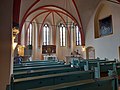
English: St.Geoerge`s Chapel in Templin municipality, Uckermark district, Brandenburg state, Germany
Deutsch: St.Georgen-Kapelle in Templin, Landkreis Uckermark, Land Brandenburg, Deutschland. Sie gehört und dient einer lutherischen Kirchengemeinde in der Evangelischen Kirche Berlin-Brandenburg-schlesische Oberlausitz.
Français : Chapelle St. Georges à la ville de Templin, arrondissement Uckermark, état fédéral de Brandebourg, Allemagne
This is the category of the Brandenburger Baudenkmal (cultural heritage monument) with the ID 09130691 (Wikidata)
|
Media in category "St Georgenkapelle (Templin)"
The following 7 files are in this category, out of 7 total.
-
 St Georgenkapelle (Templin)1.JPG 2,048 × 1,536; 1.52 MB
-
 St Georgenkapelle (Templin)2.JPG 1,602 × 1,489; 1.62 MB
-
 St Georgenkapelle (Templin)3.JPG 2,048 × 1,536; 1.47 MB
-
 Templin Georgenhospital.JPG 1,954 × 2,583; 1.33 MB
-
 Templin Georgenkapelle Georgsgruppe.jpg 4,624 × 3,456; 3.11 MB
-
 Templin Georgenkapelle Konsole 2.jpg 3,468 × 4,624; 2.04 MB
-
 Templin Georgenkapelle Konsole.jpg 4,624 × 3,456; 3.35 MB
1.JPG)
3.JPG)


