Category:St Francis Xavier school, Liverpool
Jump to navigation
Jump to search
| Object location | | View all coordinates using: OpenStreetMap |
|---|
building in Liverpool, Merseyside, England, UK  | |||||
| Upload media | |||||
| Instance of | |||||
|---|---|---|---|---|---|
| Location | Liverpool, Merseyside, North West England, England | ||||
| Heritage designation |
| ||||
 | |||||
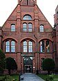
Built 1877 and run by the Jesuits. The school moved to Woolton as SFX College in 1961 and these buildings are now part of Liverpool Hope University.
Media in category "St Francis Xavier school, Liverpool"
The following 8 files are in this category, out of 8 total.
-
 Entrance to former St Francis Xavier's College, Liverpool.JPG 851 × 1,217; 1.32 MB
-
 Liverpool Hope University, Salisbury Street.jpg 2,048 × 1,536; 550 KB
-
 St Francis Xavier school, Liverpool 2019-1.jpg 4,880 × 2,414; 10.67 MB
-
 St Francis Xavier school, Liverpool 2019-2.jpg 4,681 × 3,066; 18.94 MB
-
 St Francis Xavier school, Liverpool 2019-3.jpg 4,736 × 3,169; 14.84 MB
-
 St Francis Xavier school, Liverpool 2019-4.jpg 4,302 × 3,437; 18.72 MB
-
 St Francis Xaviers (SFX) College (geograph 2489491).jpg 800 × 600; 136 KB
-
 The Cornerstone, Liverpool Hope University, Shaw Street.jpg 3,276 × 4,596; 1.27 MB


_College_(geograph_2489491).jpg)
